Early Los Angeles City Views (1800s)
Historical Photos of Early Los Angeles |
.jpg) |
|
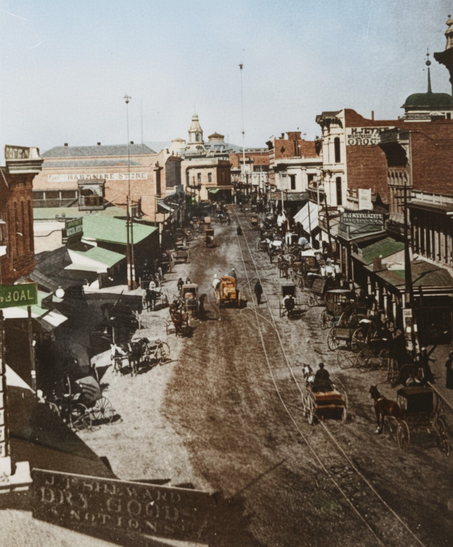
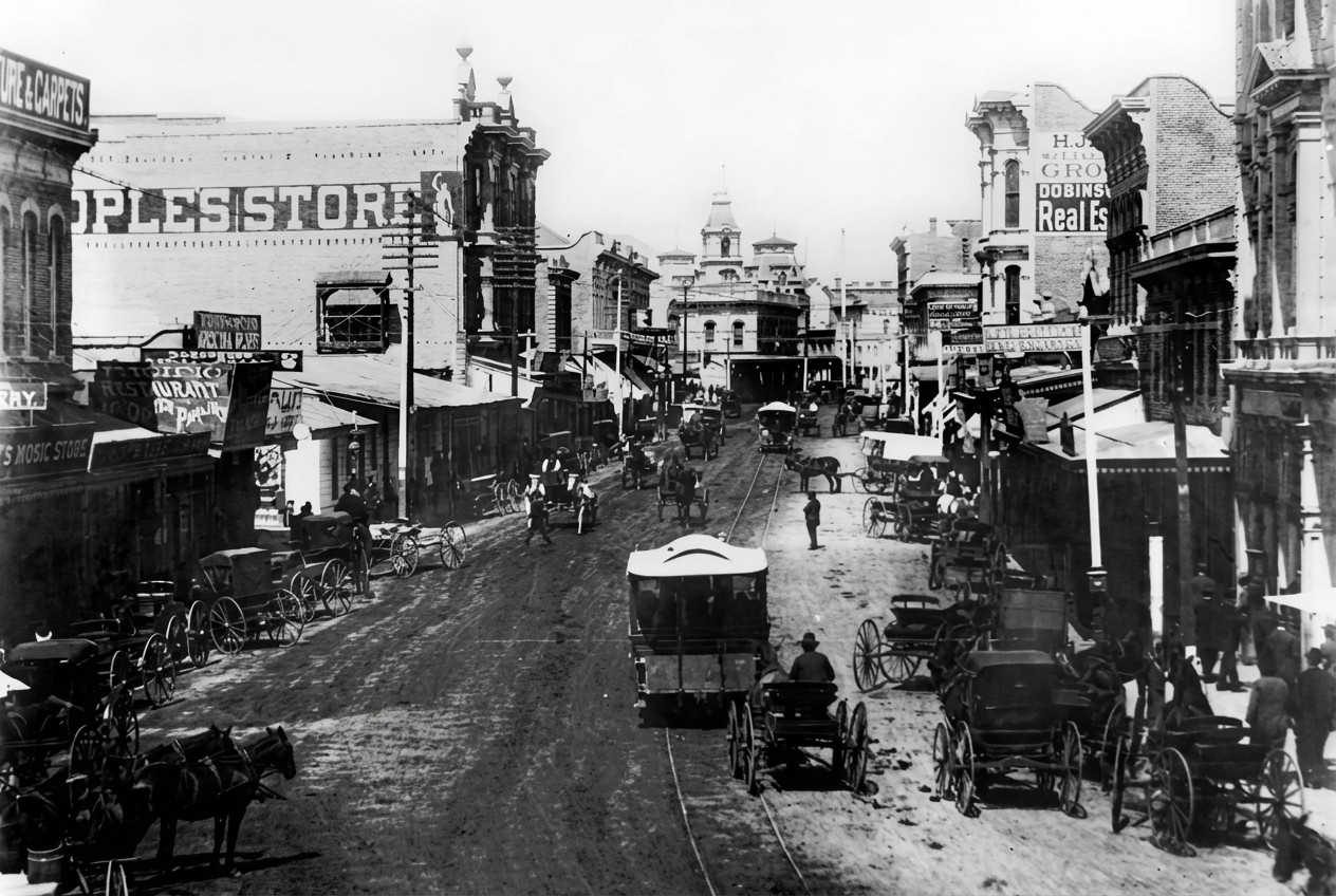
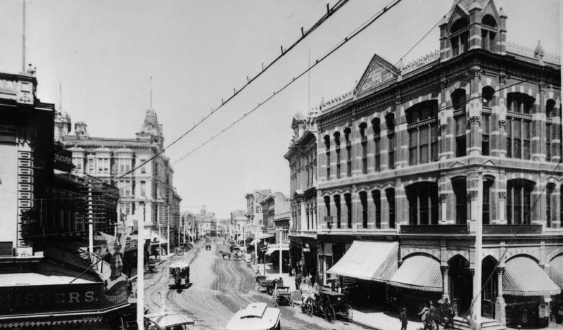
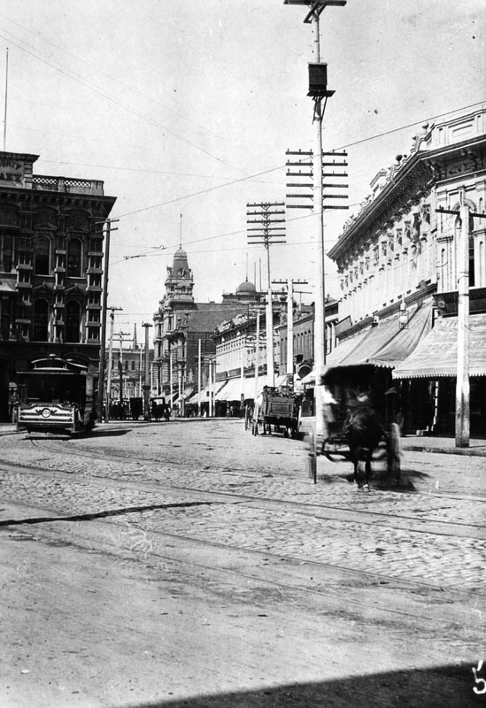
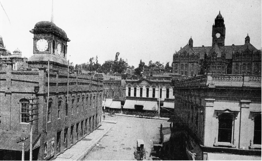
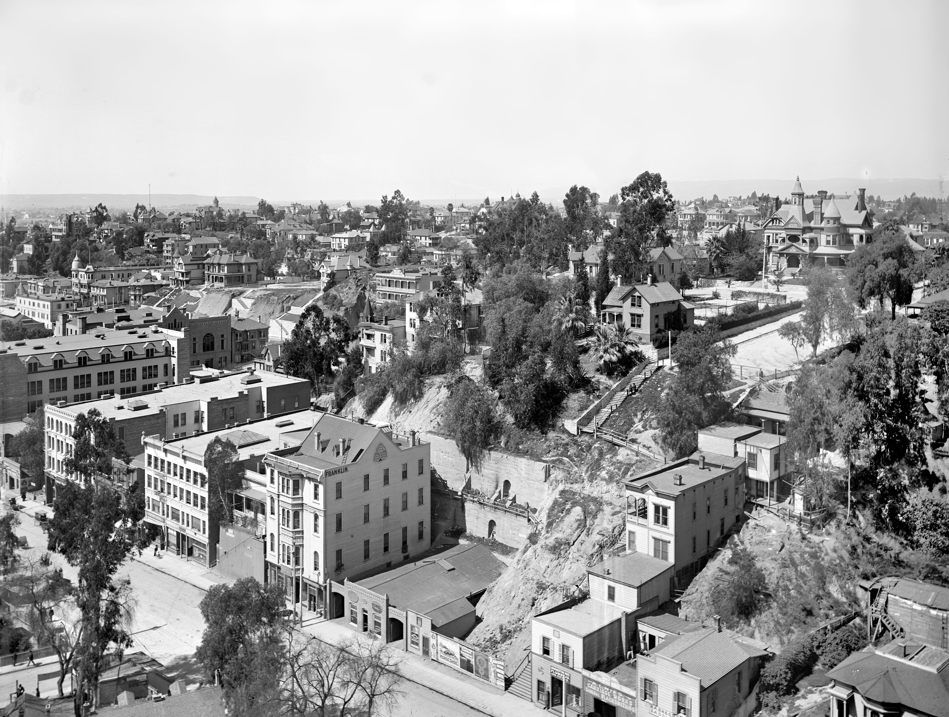
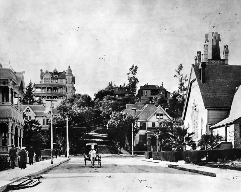
| (ca. 1883)* - Spring Street looking north as seen from the from 1st Street. H. Jevne, wholesale grocer, is seen at 40 North Spring at upper-right. The tall copula in the distance is part of the Baker Block. The copula of Temple Block can also be seen at upper-right. The tall pole in the distance is actually LA's 1st Electric Streetlights (installed in 1882). It was 150 feet tall. |
Historical Notes Spring Street north of 1st in the early 1880s still had the look of a frontier town, even as Los Angeles was beginning to push toward a more modern identity. Dirt roads, open lots, and small wooden shops lined the block. One of the most striking features is the tall electric light tower rising above the street. Installed in 1882, it was part of the city’s first attempt at electric streetlighting, long before the neighborhood had paved roads or structured sidewalks. The cupola of the Baker Block can be seen in the distance, marking the direction of Main Street and serving as one of the city’s best-known landmarks. This early view captures Los Angeles at a turning point, with old and new elements blending together. Horse-drawn wagons still dominated the street, but the electric light tower signaled the direction the city was heading. |
 |
|
| (ca. 1883)* - Spring Street brought to life — the same 1883 scene, now colorized, showing just how raw and open early downtown Los Angeles really was. |
Historical Notes The colorized version brings out details that are easy to miss in the original image. The warm tones of brick and wood, the dusty street surface, and the bright signage all help show how active the block was in 1883. On the right stands Hans Jevne’s grocery, one of the most successful food businesses in early Los Angeles. Jevne first operated out of a single storefront here, eventually expanding into both floors of the building as his wholesale and home-delivery operations grew. The color also highlights how close together the businesses were packed along Spring Street, creating a lively commercial corridor despite the rugged surroundings. Even in this early stage, you can see the beginnings of the busy district Spring Street would become. |
 |
|
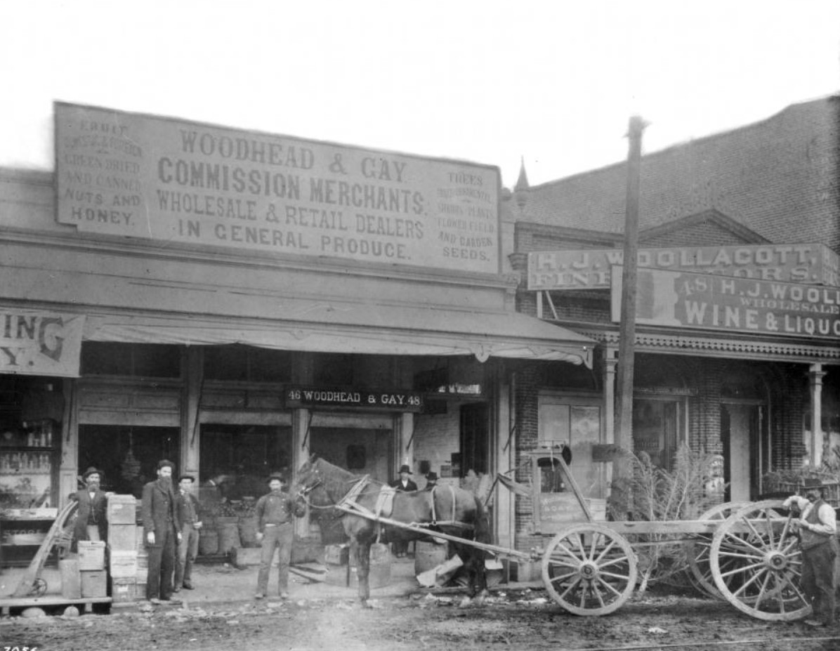
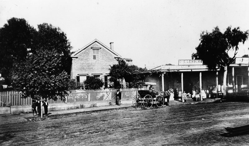
| (ca. 1880)* – View showing several people posing for the camera as they stand next to a horse-drawn wagon and in front of the Woodhead and Gay Store at 46 and 48 N. Spring Street. The tall wall in the background is the side of the 3-story building occupied by H. Jevne Grocery (see previous photo). The H.J. Woollacott liquor store is also visible to the right.; Signs include: "Fruit Domestic & Foreign / Green Dried and Canned Nuts and Honey", "Woodhead & Gay Commission Merchants. Wholesale & Retail Dealers in General Produce.", "Trees Fruit and Ornamental / Shrubs, Plants, Flower, Field and Garden Seeds.", and "H.J. Woollacott, Fine Liquors / Wholesale Wine & Liquor". Photo: C.C. Pierce |
Historical Notes This view captures everyday life on North Spring Street at a time when the street was lined with small shops serving a growing town. The Woodhead and Gay store sold fruit, produce, seeds, and plants, supplying both local families and farmers coming in from the countryside. Signs on the building advertised fresh and dried fruit, nuts, honey, and seeds of every kind. The photo also shows part of the tall wall of the H. Jevne grocery building next door, evidence that this block was becoming a cluster of food and produce businesses. The men standing near the wagon represent the small staff typical of these early stores. According to notes kept with the photograph, Mr. Bell was the bookkeeper and L. E. Myers was the head clerk. Their work would have involved long hours, direct contact with customers, and handling goods brought in by horse drawn wagons from the surrounding ranches and orchards at a time when Los Angeles was still closely tied to agriculture. |
 |
|
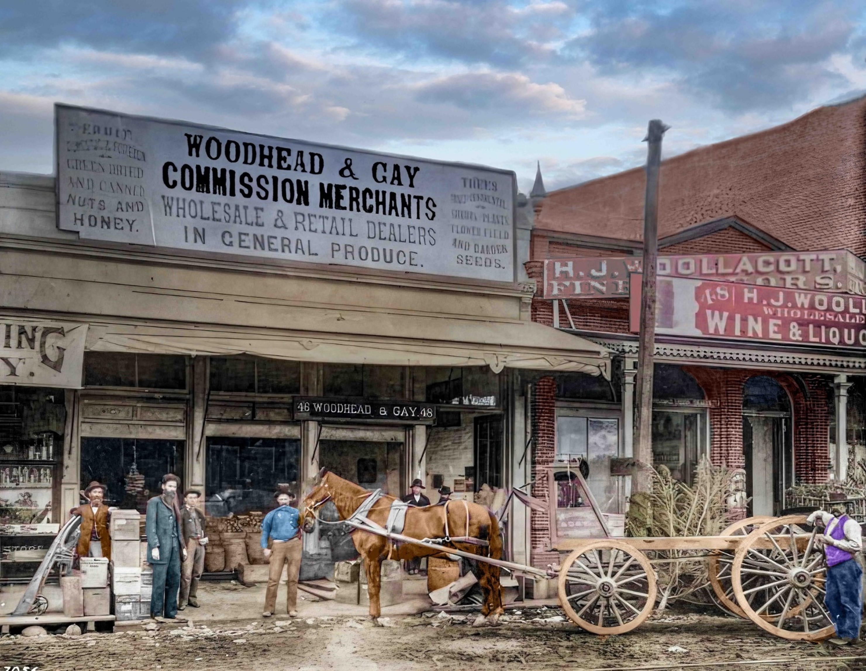
| (ca. 1880)* – View showing several people posing for the camera as they stand next to a horse-drawn wagon and in front of the Woodhead and Gay Store at 46 and 48 N. Spring Street. The tall wall in the background is the side of the 3-story building occupied by H. Jevne Grocery (see previous photo). The H.J. Woollacott liquor store is also visible to the right.; Signs include: "Fruit Domestic & Foreign / Green Dried and Canned Nuts and Honey", "Woodhead & Gay Commission Merchants. Wholesale & Retail Dealers in General Produce.", "Trees Fruit and Ornamental / Shrubs, Plants, Flower, Field and Garden Seeds.", and "H.J. Woollacott, Fine Liquors / Wholesale Wine & Liquor". Photo: C.C. Pierce; Image enhancement and colorization by Richard Holoff |
Historical Notes The colorized version brings out details in the storefronts and signage that are easy to miss in the original image. Trees, shrubs, flowers, and garden seeds were major parts of the business, showing how important home gardening and small scale agriculture were to residents. To the right, the H. J. Woollacott liquor store advertised fine wines and spirits. Stores like Woollacott’s catered to hotels, restaurants, and saloons throughout early Los Angeles. Together, these buildings show how varied commerce was along this block of Spring Street. Produce merchants, grocers, and liquor dealers operated side by side, and many shops had both wholesale and retail customers. This mixture of businesses helped Spring Street grow from a dusty road into one of the earliest commercial centers of the young city. |
 |
|
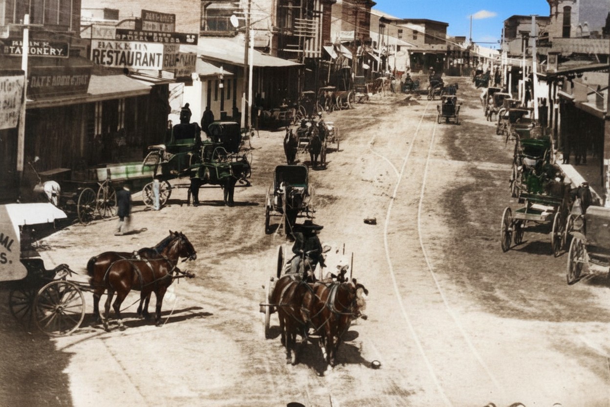
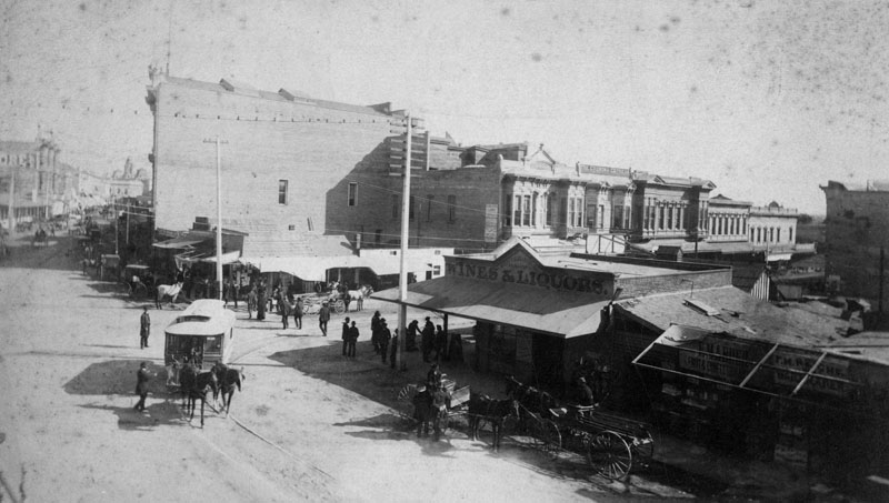
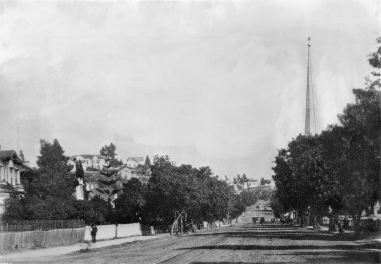
| (1885)* - Spring Street near First looking north. Horse-drawn wagons are seen throughout the commercial area on Spring Street. Large sign in the upper left reads: BAKERY - RESTAURANT |
Historical Notes By 1885 Spring Street was busier but still unpaved, with horse drawn wagons parked along the curbs and moving in every direction. The businesses seen here served a growing downtown population that depended on fresh bread, prepared food, and daily supplies. A prominent sign for a bakery and restaurant reflects the simple eating places that travelers, workers, and residents relied on before the city had more formal dining establishments. Although it has a frontier appearance, Los Angeles was already expanding quickly. Buildings were becoming larger, streetcar lines were being extended, and new banks and offices were opening. This view captures the moment just before major development reshaped the area. |
 |
|
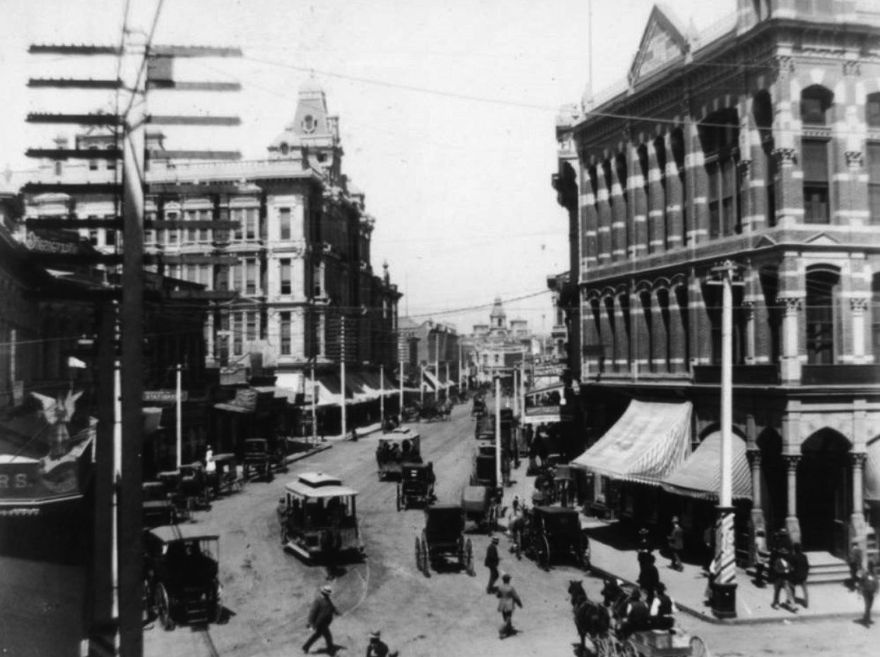
| (ca. 1885)* - View of Spring Street looking north from 1st Street. Horse-drawn carriages occupy most of the parking spots along the curbs while several horse-drawn street cars travel down the street. The A. Hamburger and Son's People's Store is seen on the left. The tall copula seen in the distance is part of the Baker Block. |
Historical Notes A. Hamburger and Sons was one of the first department stores to operate in Los Angeles. Originally known as A. Hamburger & Son's People's Store, the name later changed to Hamburger's Store. In 1908 the company relocated their store from Spring Street to a newer building located at Broadway and Eighth Street. May Department Stores acquired Hamburger's in 1923 and renamed it the May Company. |
 |
|
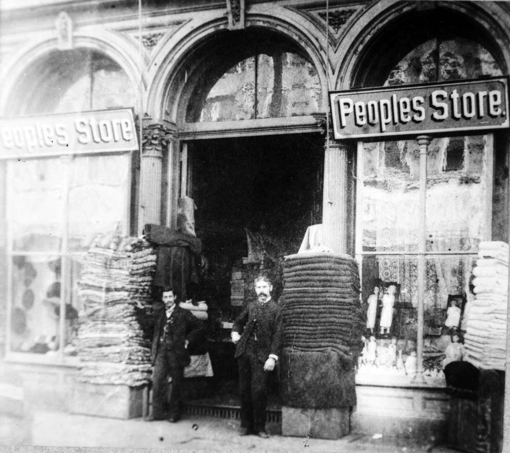
| (ca. 1880s)* – Two men pose for the camera in front of the People’s Store. |
Historical Notes People's Store (later Hamburger's Department Store) was located in the Phillips Block until 1903. It then relocated to a new, larger building located on the SW corner of Broadway and 8th Street.. At the time it was the largest department store building west of Chicago. The store was acquired from A. Hamburger & Sons Co. by David May in 1923 and renamed the May Company. |
.jpg) |
|
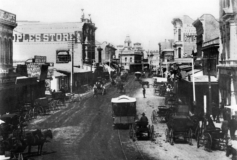
| (1885)* - Spring Street near First looking north. Schumacher Block is visible in left foreground. The copula of the Baker Block (built in 1878) can be seen in the distance. Horse-Drawn Streetcars and wagons are seen throughout. |
Historical Notes This view shows the Schumacher Block in the left foreground. John Schumacher was an early Los Angeles resident who bought the land for this block with a gold nugget he found during the gold rush. His building became one of the early landmarks of Spring Street, marking the area as a developing business district. Horse drawn streetcars and wagons fill the street, showing how transportation in the city was still dependent on animal power. The cupola of the Baker Block can be seen in the distance, rising above the older and more modest structures. Within just a few years, taller and more elaborate buildings would replace much of this early streetscape as Los Angeles entered a period of rapid growth. |
 |
|
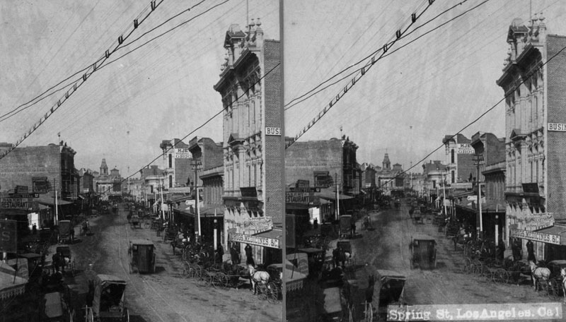
| (ca. 1884)^ - Stereoscopic view of Spring Street looking north. Horse and buggy transportation is seen on the unpaved road. |
Historical Notes This stereoscopic image captures Spring Street when it was still unpaved and lined with small shops. The view shows an active mix of wagons, riders, and pedestrians. Despite its rough appearance, this stretch of Spring Street was already becoming one of the main routes through downtown Los Angeles. The mix of frame buildings and newer brick structures shows a city in transition. Residents depended on horses for transportation, and streets were often dusty in summer and muddy in winter. Scenes like this changed quickly as street grading, paving, and electric lighting began to spread through the district. |
 |
|
| (1884)^ - Looking north on Spring and east on First Streets in 1884. Horse-drawn streetcar can be seen turning onto Spring Street. The sign on the building (right-center) reads: WINES & LIQUORS. The short-lived Los Angeles National Bank Building was constructed on the NE corner in 1887. In 1906, it was replaced with the 7-story Equitable Savings Bank Building. |
Historical Notes This view looks north on Spring Street and east on First Street. A horse drawn streetcar is seen turning the corner, serving riders who needed a dependable way to travel between the growing residential neighborhoods and the business district. The building on the right bears a simple Wines and Liquors sign. Such establishments were common on the edges of commercial centers and catered to both travelers and workers. The empty corner at the northeast would soon become the site of the Los Angeles National Bank Building in 1887. That bank building, later replaced by the Equitable Savings Bank, marked the beginning of a more formal financial district along Spring Street, which would eventually become known as the Wall Street of the West. |
 |
|
| (1887)^ - Spring St. looking north from Nadeau Hotel located on the southwest corner of 1st and Spring. Los Angeles National Bank is on the northeast corner (on the right), near where City Hall is today. The ornate 4-story building at center-left is the Phillips Block, built in 1887. Horse-drawn streetcars and carriages can be seen throughout. |
Historical Notes The 1887-built, 4-story Phillips Building replaced another large building at the same location (seen in previous photos) that housed Hamburger & Son's People's Store, at the time, LA's largest Department Store. The People's Store would remain in the new ornate Phillips Block building until 1908, when the store moved into its newly constructed building on the SW corner Broadway and 8th Street. May Department Stores would acquire Hamburger's in 1923 and rename it the May Company. |
 |
|
| (ca. 1888)^ - View looking down Spring Street from 1st Street. Los Angeles National Bank Building is on the northeast corner on the right. Down the block (center-left) is the 1887-built French Renaissance-style Phillips Block who's main tenant was the Hamburger & Son's People's Store. In the far distance can be seen the main cupola of Baker Block located on Main Street. |
Historical Notes Completed in 1887, the Los Angeles National Bank Building was designed by Kysor & Morgan in the "Modern Gothic" style, included a basement and cost $65,000 to build. The building materials were granite, iron and pressed brick. The bank was organized in 1883 and later merged, along with Southwestern National Bank, with First National in 1905. The Equitable Savings Bank then occupied the premises and replaced the building with a seven-story structure (Equitable Building).
|
Then and Now
 |
|
 |
|
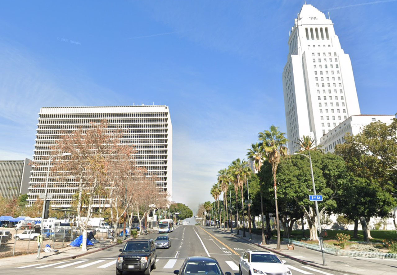
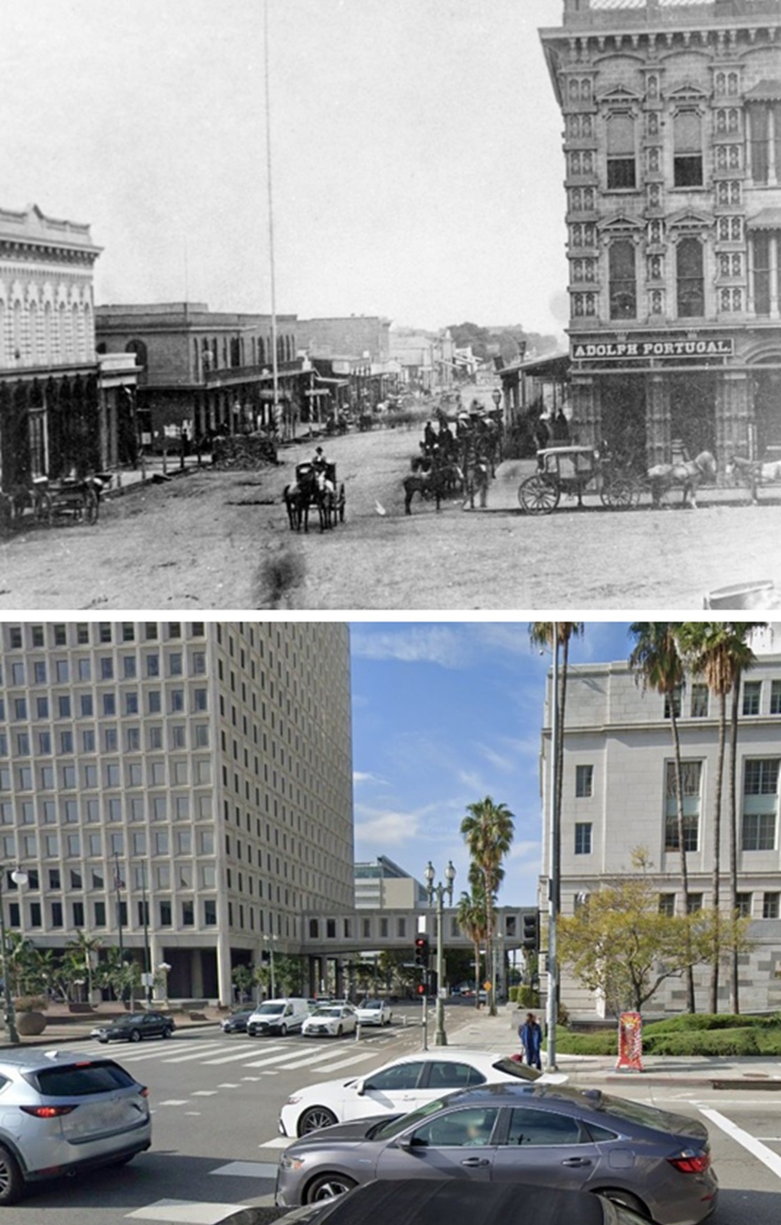
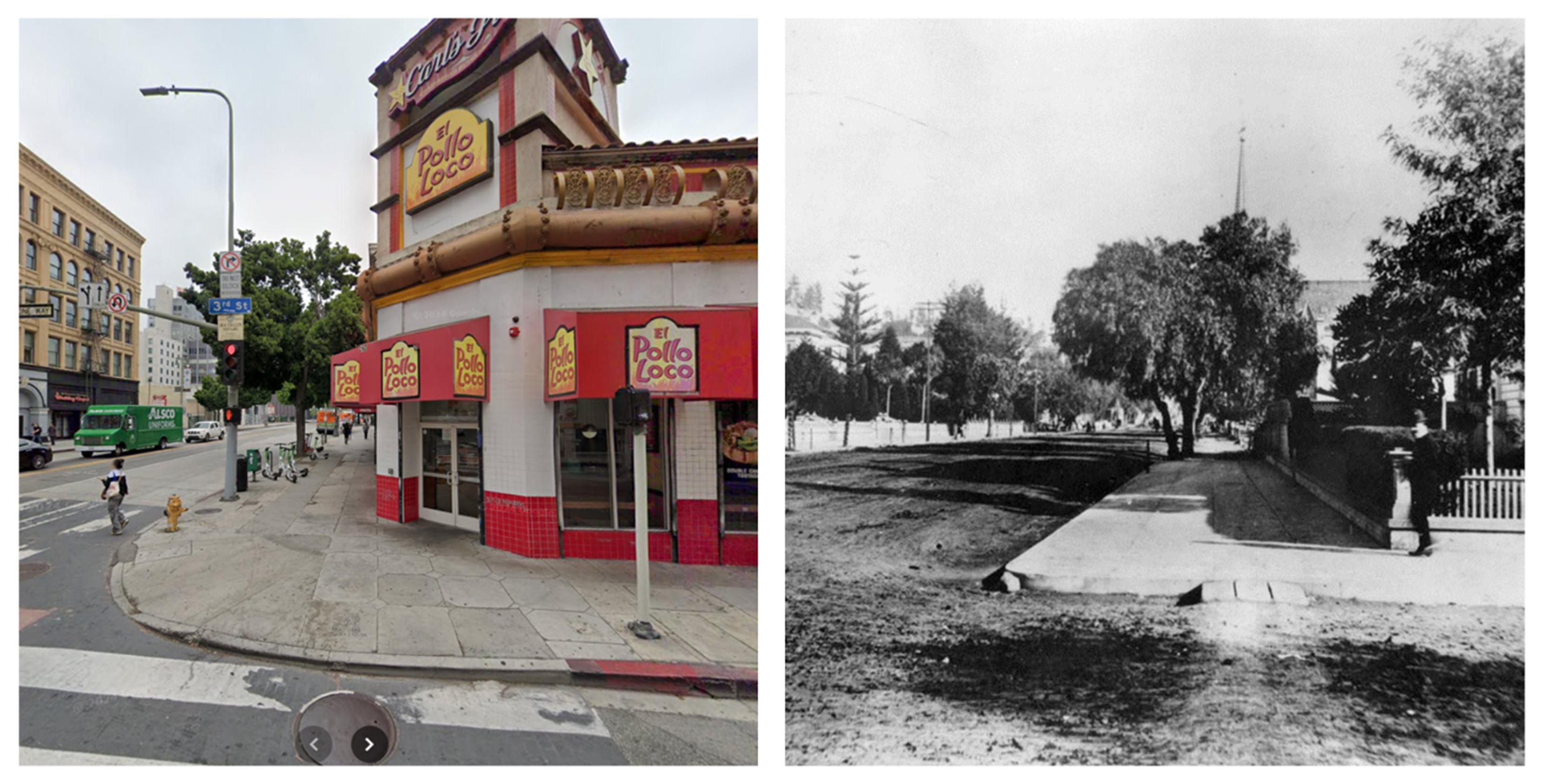
| (1885 vs. 2021) - Spring Street looking North from 1st Street. Photo comparison by Jack Feldman. |
Historical Notes The 1885 view of Spring Street shows a young Los Angeles that still felt close to its frontier beginnings. The street was unpaved and filled with wagons, horses, and early streetcars. Small shops, produce dealers, and simple brick buildings lined both sides of the block. In the distance the tall cupola of the Baker Block rose above the older structures, serving as a landmark for people traveling through the city. Spring Street at this time was only beginning to develop into a commercial corridor, but the growing presence of banks, grocery houses, and department stores showed that change was on the way. The modern view tells a very different story. Spring Street has long since been paved, widened, and rebuilt with taller buildings that reflect the growth of Los Angeles from a town of a few thousand residents into a major metropolitan center. Little remains of the early streetscape. The skyline is filled with office buildings, and City Hall now stands just beyond the point where the early bank buildings once sat. What was once a dusty road lined with wagons has become a fully developed urban street, yet the angle of the view still follows the same alignment that early residents knew well. |
 |
|
| (1927)* - Map comparing Spring Street’s original alignment with the new route created to clear space for Los Angeles City Hall. |
Historical Notes Spring Street was realigned in 1927 to accommodate construction of the new City Hall. By 1931, the street would also be extended north of Temple Street all the way to Sunset Boulevard, removing most of the buildings in its path—including the Los Angeles County Jail. Click HERE to see more. |
* * * * * |
First Street (looking East from Hill Street)
 |
|
| (ca. 1870)^ - Looking east on First Street toward Broadway. |
 |
|
| (1884)^^ - Panoramic view looking east on First Street from Hill Street, showing the 4-story Nadeau Hotel located on the southwest corner of First and Spring streets. |
Historical Notes The photograph's dominant structure is the Hotel Nadeau, while the Natick House can be seen further east on First and Main Streets. The photograph features the following buildings: De Turk's Livery, Feed & Sale Stable (built before 1880), it's a larger building at lower left, on the north-west corner of First Street and Broadway; Hotel Nadeau (1882-1931), a large building in right center, located at the southwest corner of First & Spring Streets; Larronde Block (built in 1883), located across First Street from Nadeau Hotel, on the north-west corner with Spring Street. Schumacher Block (1880 - ca.1931), to the left of the Larronde Block, on Spring Street. Natick House (built in 1883), to the left of Nadeau, on the southwest corner of First and Main Streets; Pithian Castle Block (built in 1877) can be seen directly above Schumacher Block, with tall, narrow windows, located on Spring Street just north of First Street.^^ |
Spring and 1st Street
 |
|
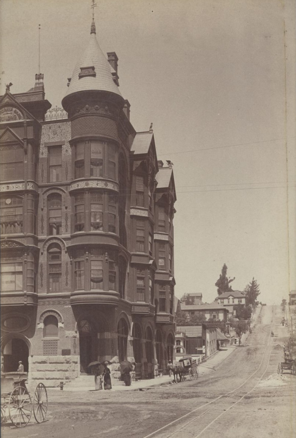
| (1886)^ - View of the Nadeau Hotel on the southwest corner of Spring and 1st streets. A row of horses & carriages is lined up on the street in front. A tall narrow church spire can be seen in the background on the far left. |
Historical Notes Remi Nadeau was a French Canadian pioneer who arrived in Los Angeles in 1861 driving a team of oxen. During the silver-mining excitement in the Cerro Gordo region of Inyo County his teamster operation brought tons of silver to Southern California and hauled back food and supplies to the miners. By 1873 he operated 80 such teams. In 1882, Remi Nadeau built the Nadeau Hotel, Los Angeles's first four-story structure and the first building with an elevator. The hotel was designed by Morgan & Walls. |
Spring and 2nd Street
 |
|
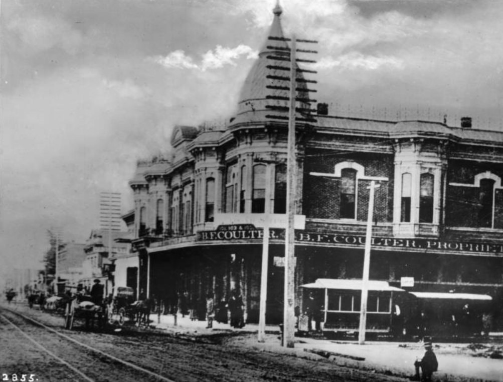
| (1886)* - View of the southwest corner of Spring and Second streets showing the B.F. Coulters store on the ground floor of the Hollenbeck Hotel. A streetcar is stopped along Second Street. A series of utility poles are visible looking up Spring Street in front of the store. Horse-drawn wagons, carriages, and pedestrians are on the dirt street and sidewalk. Legible signs include: "101, 103 & 105, B.F. Coulter, proprieter"; "Coulters Store in the Baker Block is to be closed Feb. 1 and all business of the firm will hereafter be done in the Hollenbeck block, corner Spring & Second Streets" -- 10 January 1886. |
Historical Notes B. F. Coulter was one of the earliest merchants in Los Angeles. The Coulter's Dry Goods business dates from 1878 and later was called Coulter's. Coulter was an ordained minister and founded the Broadway Christian Church. The business was continued by B.F. Coulter's son-in-law, R. P. McReynolds, and his son, James McReynolds. |
Main Street
 |
|
| (1883)^ - A group of men are seen posing for the camera in the middle of Main Street. The view is looking south on Main Street with the Pico House on the left. The tower of the Baker Block can be seen in the background. |
Historical Notes The tall pole seen between the two men sitting on the wagon is not a flagpole. It is a 150-foot electric street light mast that was one of the first to be installed in the City of Los Angeles. Click HERE to read more about it in Early Los Angeles Street Lights. |
 |
|
| (ca. 1880s)^ - Main Street looking north from atop the Temple Block. Baker Block is just right of center. This vantage point is now occupied by City Hall. The tall poll (center right) is one of the first of seven electric light poles installed in the City of Los Angeles. They were 150 feet tall! |
Historical Notes Each of the 150-foot-high masts carried three electric lights of three thousand candle-power. All seven lamps and a small power plant to provide the electricity were installed by C. L. Howland who later formed the Los Angeles Electric Company. By 1883, Los Angeles became the first city in the USA to entirely abandon gas for street lighting and replace it with electricity. The Los Angeles Electric Company later became the Los Angeles Gas and Electric Corporation and survived until it was bought out by the DWP in 1936. |
 |
|
| (ca. 1882)^ - Main Street looking north from Commercial Street. A number of horse-drawn vehicles are in the street as well as parked at the curb. The St. Charles Hotel is on the right.The City's new 150-ft. tall streetlight pole can be seen in center of photo. |
 |
|
| (1882)* - One of the first of seven electric street lights installed in the City of Los Angeles at Main and Commercial in 1882. A man can be seen standing on a platform half-way up the pole. |
Click HERE to see more in Early Los Angeles Street Lights |
* * * * * |
Spring and Temple Streets (looking West)
 |
|
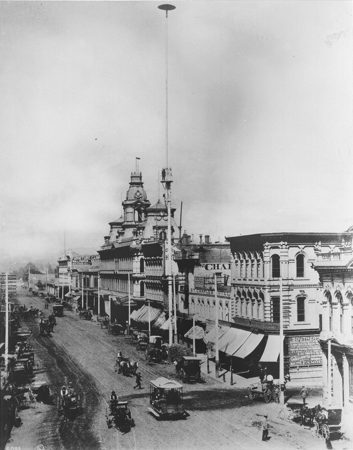
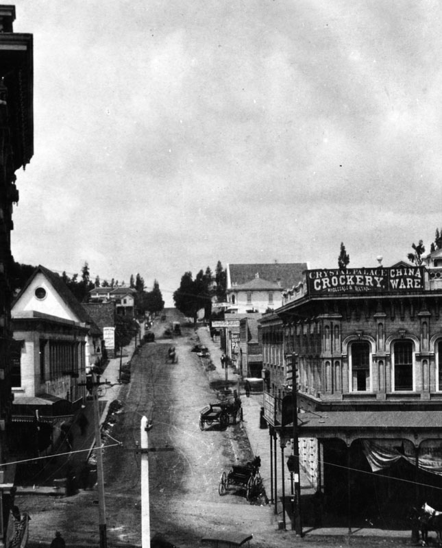
| (ca. 1884)* - View of an unpaved Temple Street, looking west from the second floor of the Temple Block on Spring Street. Horse-drawn carriages and wagons are parked along the street. In the right foreground is the Downey Block on the northwest corner, housing the Crystal Palace, wholesale and retail sellers of crockery and china ware. Behind it is the Temple Street Stables. Poles strung with electric wires are seen in the foreground. |
 |
|
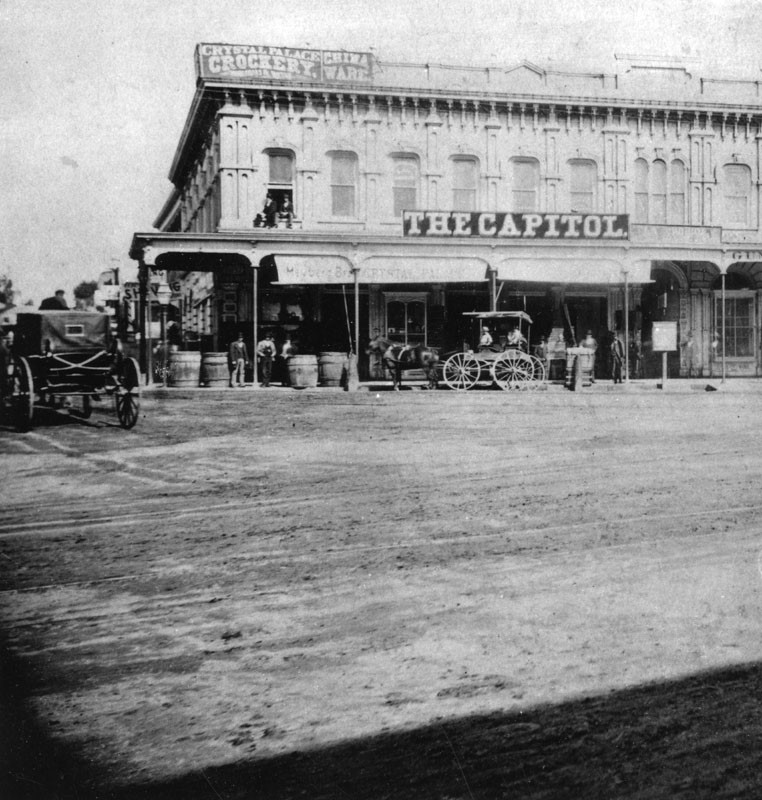
| (1880s)^ – View of the Crystal Palace Crockery store located on the northwest corner of Temple and Main streets as seen from the front of Temple Block. The building, also known as Downey Block, is two stories with a large sign over the portico that reads: THE CAPITOL. Two men are sitting on the window ledge at upper left-center. A horse and buggy is parked in front of the building while another appears to be moving west on Temple. |
* * * * * |
Main, Temple, and Spring Street Junction
 |
|
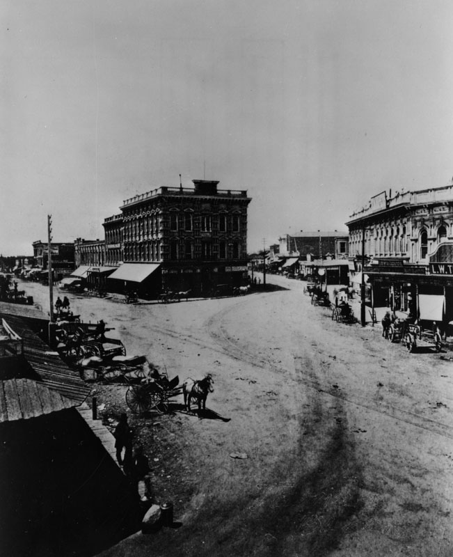
| (1870s)* - A view of Temple Block at the junction of Main, Temple and Spring streets in 1870. Horse-drawn wagons and carriages can be seen on both sides of the street. The Downey Block is at the right of photo. |
Historical Notes Main Street was dedicated in 1849. The community's first Calle Principal connected the San Gabriel Mission with the San Fernando Valley and many established ranchos. One section near the Plaza was known as Bath Street after, legend has it, the facilities featuring "scarlet women." Spring Street was dedicated in 1849. As legend has it, it was named Calle Primavera by Lt. Ord to honor his sweetheart in Santa Barbara, Trinidad Ortega, whom he called "Primavera," Spanish for "Springtime." He never married Ortega, the granddaughter of Jose Francisco Ortega, the Spanish explorer who "discovered" San Francisco Bay. Temple Street was named after John Temple in 1859, who opened the first store in Los Angeles. He built a block of shops, lawyers' offices and a saloon at Main and Temple streets, where Los Angeles City Hall stands today. |
 |
|
| (n.d.)* - Temple Square (Temple Block) appears at the bottom-center of this photograph of a model of old Los Angeles. This would become the future site of the current City Hall. |
Historical Notes Spring Street was realigned when construction of the new City Hall began in early 1927. Spring now runs parallel to Main, and intersects with Temple where the current 28-story City Hall building is now located. |
 |
|
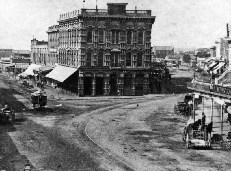
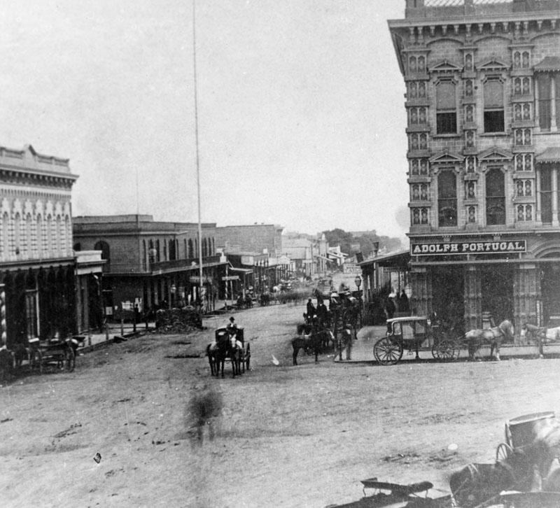
| (ca. 1876)* - Spring Street at junction of Main Street, circa 1876. A sign on the three story building (Temple Block) at the head of the junction reads "Adolph Portugal". A few horse-drawn vehicles can be seen. |
Historical Notes The Italianate Temple block was built in 1871 by Francis Pliny Fisk Temple on the site of the old Temple Block, inherited from his older brother John in 1866. It was commonly known as the Lawyer's Block as so many attorneys had offices there. The old Clocktower Couthouse, at that time, was situated immediately to the south. As there was very little waiting room at the courthouse, attorneys went back to their offices until their cases came up. They were summoned by a court clerk hollering their names out the second-story windows of the court. |
 |
|
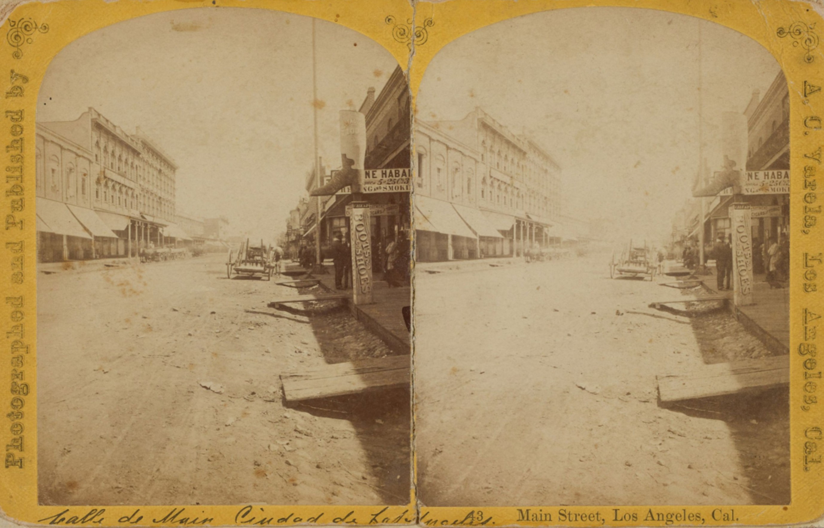
| (ca. 1878)* – Stereoscopic image looking north on Main Street in downtown Los Angeles, just south of Requena Street (later Market Street). At center left stands the northernmost three-story Italianate section of the Temple Block, with two adjacent buildings of decreasing height that also formed part of the Temple Block complex. The nearest two-story structure housed the Wells Fargo & Co. Express office at the time. At right, notable storefront signage includes a sculpted boot above a “Boots & Shoes” sign, and a partially visible tobacco advertisement reading “Fine Habanas – King of Smokers.” A horse-drawn wagon, wooden plank sidewalks, and a rutted dirt street complete the scene. Photograph by Alexander C. Varela, from the Ernest Marquez Collection. |
Historical Notes Main at Requena in the 1870s was a center of activity—hosting hotels, saloons, shops, and services that catered to residents, travelers, and laborers. The area was beginning to see more substantial construction, moving away from adobe to brick, signaling Los Angeles’ ambitions as a growing city. |
 |
|
| (ca. 1878)* – View looking north on Main Street, just south of Requena Street (later Market Street). At center left stands the northernmost three-story Italianate section of the Temple Block at the Main, Temple, and Spring Street Junction. |
Historical Notes In the 1870s, the intersection of Main Street and Requena Street (later renamed Market Street) in downtown Los Angeles was a bustling hub reflecting the city’s early urban development. The U.S. Hotel, built in the early 1860s on the southeast corner, was a prominent landmark serving mainly working-class patrons and was known for its Italianate architecture and affordable meals. Requena Street, named after an early local mayor, was an important east-west thoroughfare near the original Plaza, surrounded by a mix of adobe and brick buildings with dirt roads and horse-drawn vehicles typical of the era. This area captured the city’s transition from a frontier settlement to a growing commercial center. |
 |
|
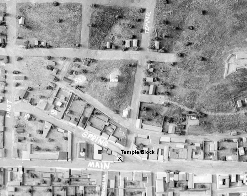
| (n.d.)* - Model of Early Los Angeles with annotation showing the location and direction of the previous photo. The blue arrow indicates the photographer’s vantage point, looking north up Main Street, just south of Requena Street (later Market Street). |
Historical Notes North is to the right in this view. Today, this spot would place you between Los Angeles City Hall (to the left) and City Hall East (to the right). |
Then and Now
 |
|
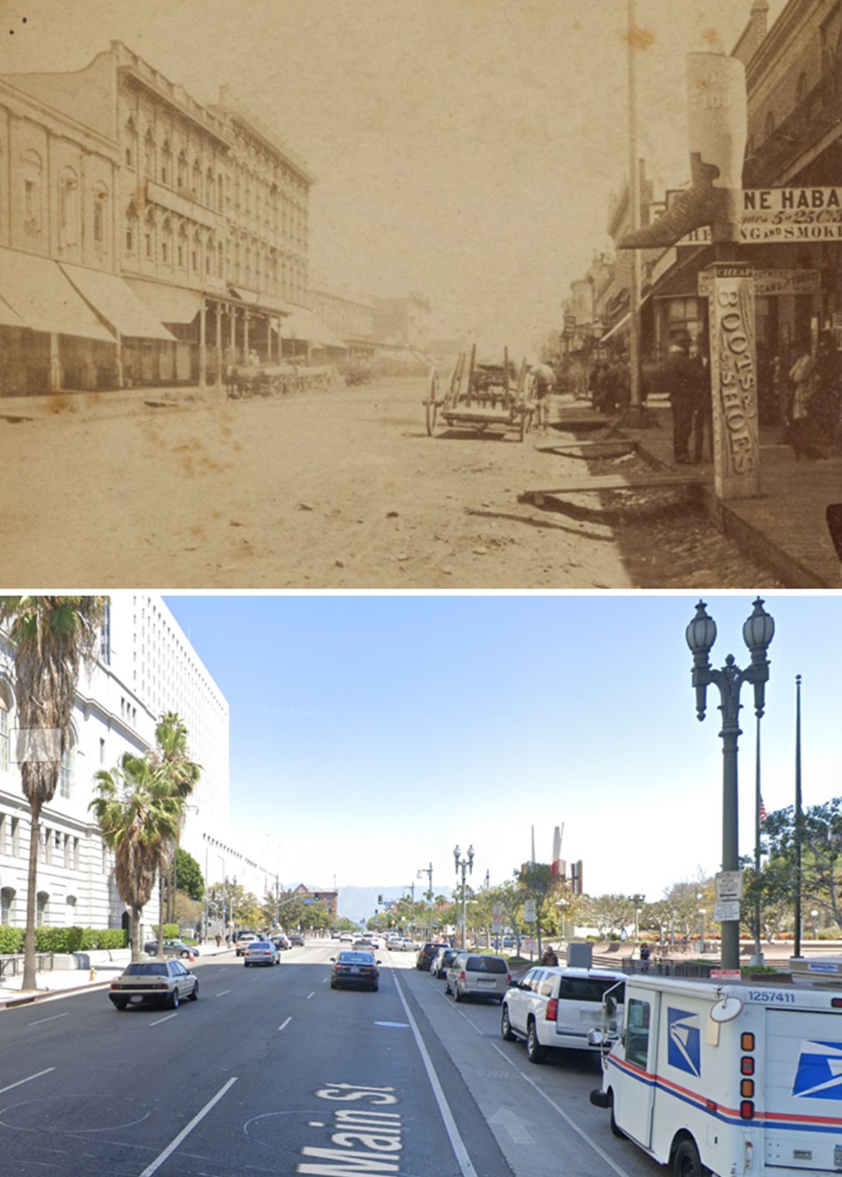
| (1878 vs 2018)* - Then and Now – Main Street Looking North Toward Temple Street. The 1878 view looks north up Main Street from just south of Requena Street (later renamed Market Street), with the Temple Block visible at center left. In the modern 2018 view, Market Street has vanished—its former path now occupied by the broad expanse of City Hall East. On the left stands the main Los Angeles City Hall, a landmark of the Civic Center since 1928. Photo comparison by Jack Feldman. |
Historical Notes The intersection of Market (originally Requena) Street and Main Street was once a vibrant part of old Los Angeles, anchored by the U.S. Hotel and Amestoy Building. Today, the site is part of the Los Angeles Civic Center, with City Hall East occupying the former locations of these historic structures. Market Street itself has disappeared from the map at this location, a casualty of mid-20th-century urban renewal. |
 |
|
| (1880s)* - View looking south on Main Street at Temple Street, with the Temple Block and Adolph Portugal’s store visible at right. Requena Street can be seen intersecting Main Street near the tall pole in front of the U.S. Hotel. |
Historical Notes Main Street was one of the primary thoroughfares in early Los Angeles, running through the heart of the city and connecting various important locations, including the Plaza. It was a central axis for commerce and transportation, playing a crucial role in the city's expansion. |
 |
|
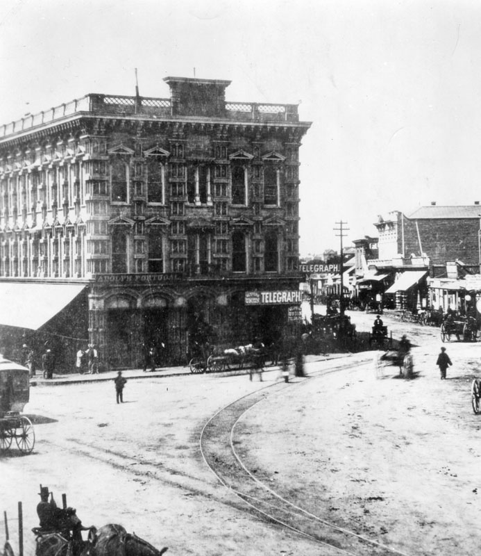
| (ca. 1880s)* - View of Temple Block at the junction of three streets; Temple, Spring and Main streets. A telegraph office is now in view at the southeast corner of Temple Block. |
Historical Notes Temple Block would become the site today's Los Angeles City Hall, built in 1928. |
 |
|
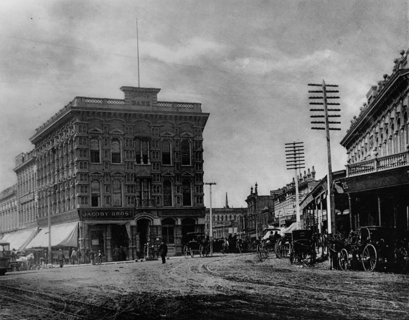
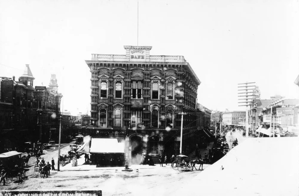
| (ca. 1885)* - The junction of Main, Spring and Temple Streets, showing Jacoby Brothers clothing store and the Los Angeles County Bank in the Temple Block. The Downey Block on the right was on the northwest corner of Main and Temple. Telegraph poles are seen throughout. |
Historical Notes The Jacoby family came from Loebau, Poland, a territory at the time controlled by Prussia. They arrived in the United States at different times during the 1870s. The five Jacoby brothers started business in Los Angeles in the 1870's by joining with Leopold Harris and buying out Herman W. Hellman’s store. Hellman left after 5 years and the firm became The Jacoby Brothers and flourished well into the first third of the 20th Century. Jacoby Bros. kept growing until it was one of the largest retail and wholesale companies in Los Angeles. In the mid-1920's it sold out to David May of the May Company of St. Louis. This occurred about the same time as when the Hamburgers Department Store was also sold to the May Co. |
 |
|
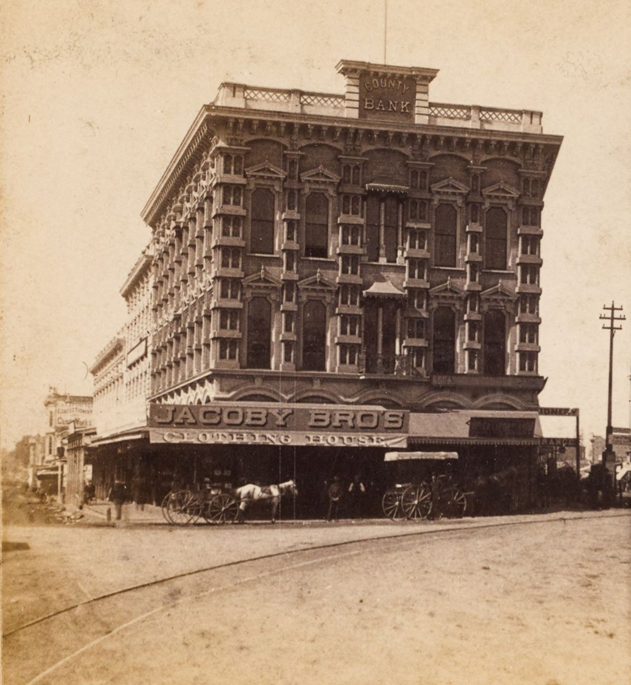
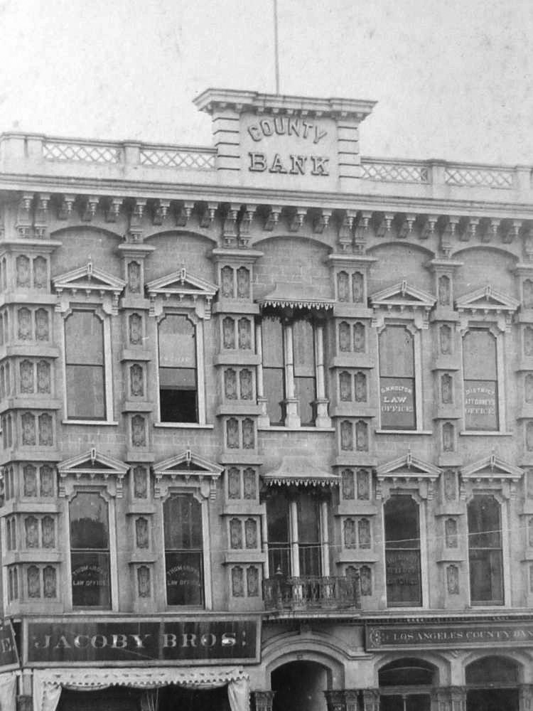
| (ca. 1881)* - View of the three-story Italianate Temple Block building with horse-drawn carriages in front, at the intersection of Main Street and Spring Street in downtown Los Angeles, with visible signs on the building for "Jacoby Bro's Clothing House," "County Bank." "California Confectionary and Candy Works" can be seen on a building on Main Street in the background at left. Ernest Marquez Collection |
 |
|
| (ca. 1885)* - Close-up view of the Temple Block showing its ornate Italianate architecture, including paired columns, bracketed cornices, and decorative window hoods. |
Historical Notes Francis Temple formed a bank with his English-born father-in-law, William Workman, The Temple & Workman Bank. The bank was in the space occupied by the Los Angeles County Bank in the photo above. The bank closed during the panic of 1875, brought on by the failure of the Bank of California in San Francisco. Temple managed to secure a loan to reopen the bank from the ruthless "Lucky" Baldwin, a San Francisco financier who had become interested in investing in Southern California. The terms of the loan were extremely harsh, Temple and Workman pledged everything they had, including their homes, ranches, downtown commercial property and Temple Block itself. However, the bank failed for a second time in 1876. Baldwin, refusing to renegotiate the loan, quickly closed in. Temple and Workman were ruined. Workman, then 76 and a former Mayor of Los Angeles, killed himself. Temple, under extreme stress following his losses, had a stroke, finally dying in 1880. He left his wife and seven children. The Temple & Workman family fortunes were restored in 1914 when Temple's nine-year-old grandson (Workman's great-grandson), Thomas Workman Temple II, discovered a natural gas deposit while playing on land his father owned. The families developed Montebello Oil Field there in 1917. With their renewed funds the families were able to recover their ranch, La Puente (City of Industry) including their private family cemetery, El Campo Santo. Temple and Workman are buried there along with their families and their friend, Pio Pico and his wife. |
 |
|
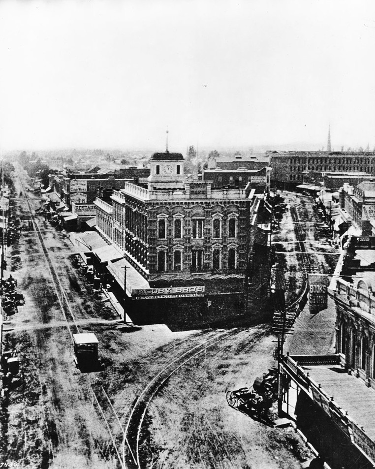
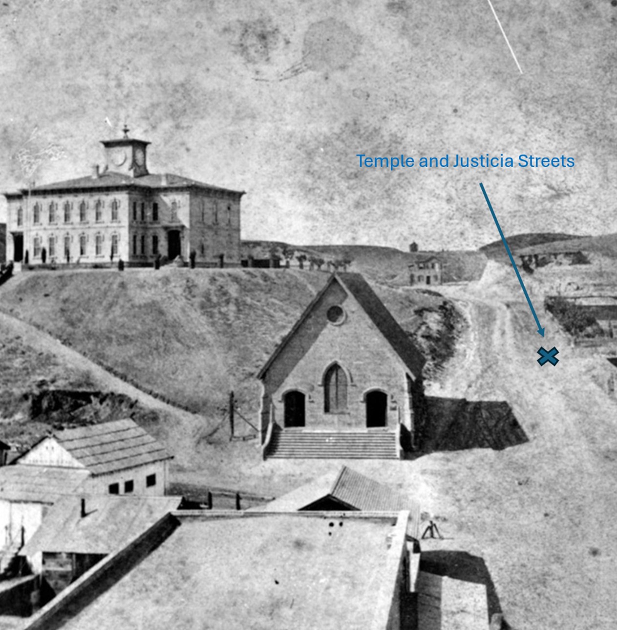
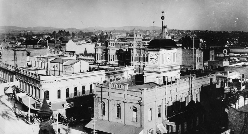
| (ca. 1885)* - View looking south with a good view of Main Street (left) and Spring (right). The old County Courthouse with its cupola and clock can be seen in the center of Temple Block. |
Historical Notes The old County Courthouse was originally built by John Temple in 1858 as a marketplace and theater. Its first floor was used for that purpose for a number of years, and the second floor was the first theater in Los Angeles. Between 1860s-1884, Los Angeles City Hall shared space with the County Courthouse in the Temple Block. |
 |
|
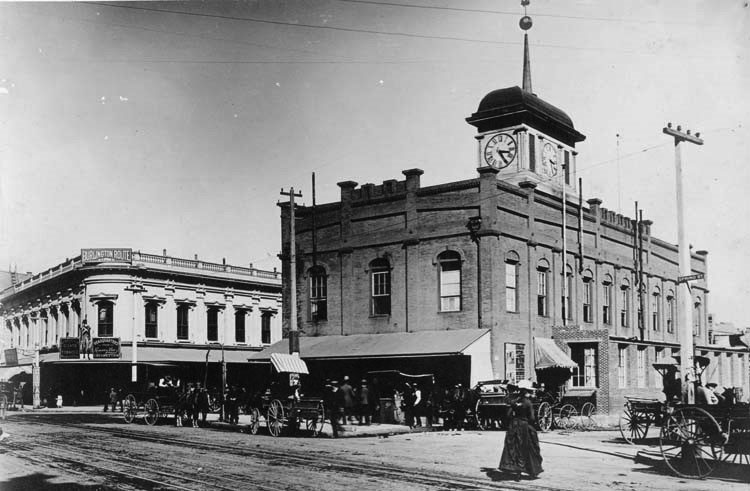
| (1887)* - View looking south from Temple toward Temple Block. Main Street is on the left and Spring Street on the right. Note the fountain in front of Temple Block. |
Historical Notes In 1882, the fountain in front of Temple Block was donated by Harris Newmark of Newmark & Co. and the water was provided free by the LA Water Company. The Newmark Fountain was a minor landmark in downtown Los Angeles between 1882 and 1892. The female figure atop it was nude, which made it an object of some interest at the time. Unfortunately, the fountain met a premature end when a team of runaway horses hit it in 1892. Harris Newmark was a successful businessman in early Los Angeles. He made many contributions to the economy and culture of Los Angeles, and gave his time and his money to causes he felt were worthy. He was one of the founders of the Los Angeles Public Library, was a charter member of the Los Angeles Chamber of Commerce, and was one of the organizers of the Board of Trade, which helped bring railroad service to California. He was the president of Congregation Congregation B'nai B'rith in 1887 and a founder of the Jewish Orphans Home. Newmark was also instrumental in the establishment of the Southwest Museum, which is now part of the Autry National Center. He and other Newmarks were leaders of the local Odd Fellows and were Masons. |
 |
|
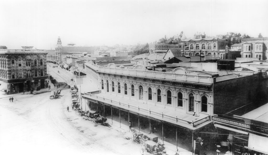
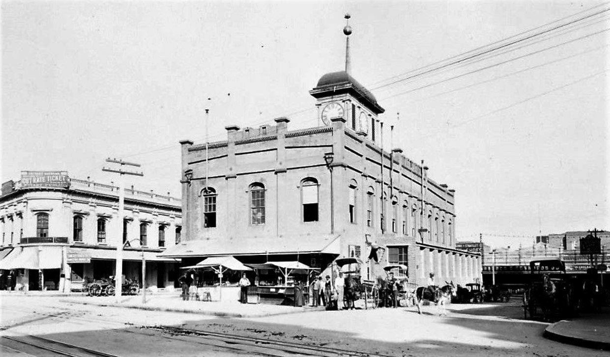
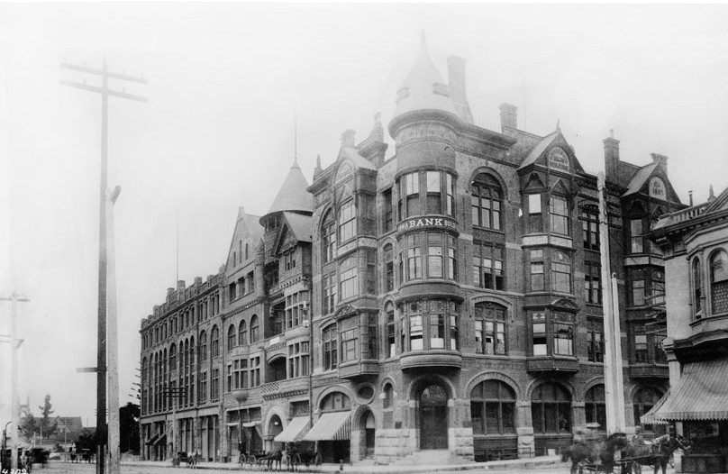
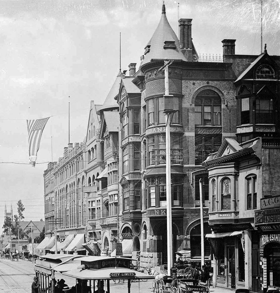
| (ca. 1887)* - View looking down Spring Street from near where Main, Spring, and Temple streets intersect. The Downey Block with horse-drawn carriges and wagons parked in front is seen on the right. At left is the Temple Block. Further down Spring Street can be seen a 4-story building with a unique copula. That is the Phillips Block. |
Historical Notes Construction on the Downey Block began in 1869. It was named for John Gately Downey, a pharmacist who served as the governor of California for two years (1860-1862) before becoming a real estate developer. Downey was also one of the founders and first president of Farmers and Merchants National Bank. The city of Downey was named in his honor after he subdivided his land holdings there and converted them into farms. |
 |
|
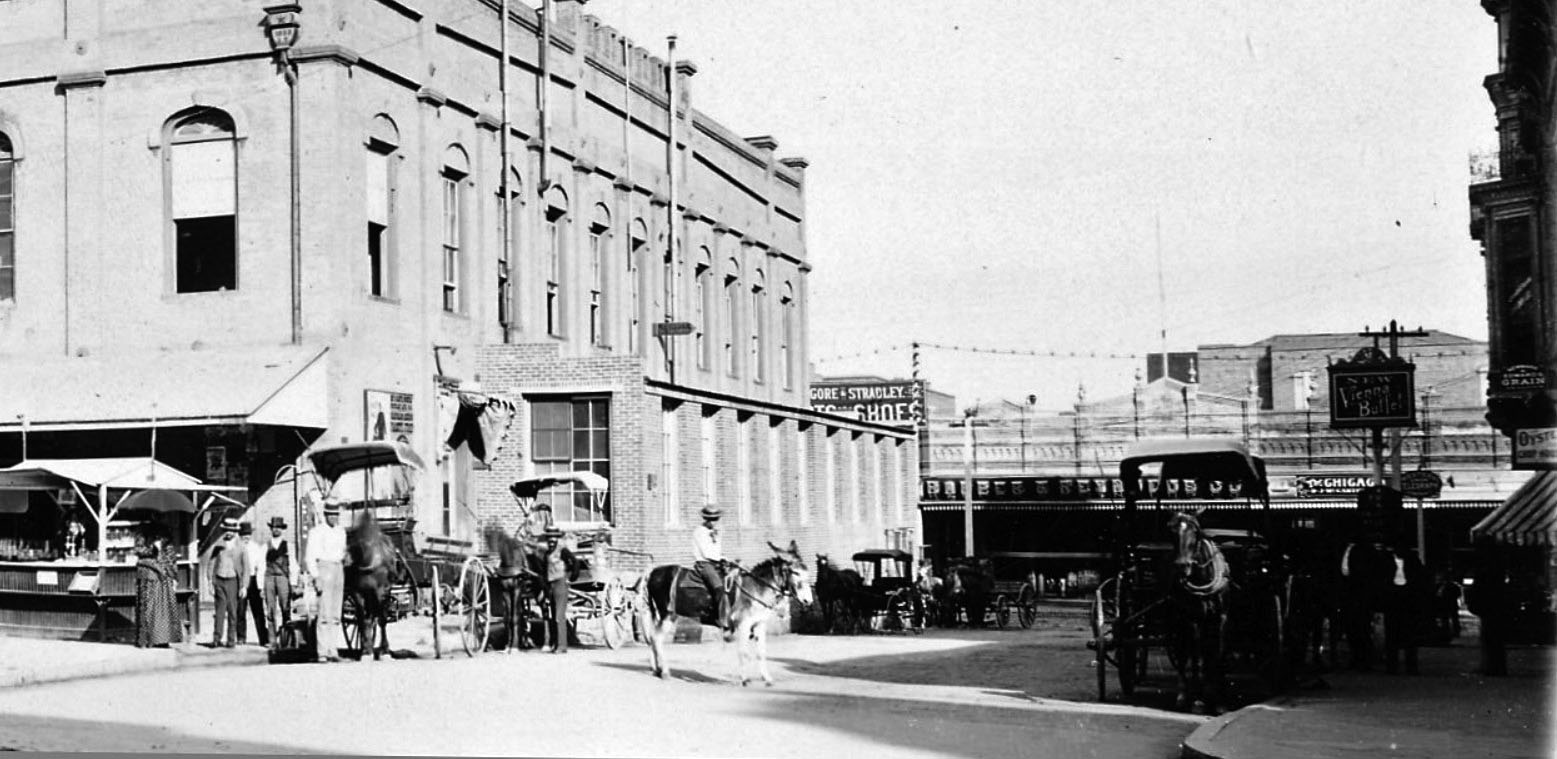
| (ca. 1887)* - View looking south on Spring Street with Temple Block seen on the left. The large 4-story building with the copula in the distance is the Phillips Block. The large, ornate four-story building housed one of the City's first department stores called Hamburger & Son's People's Store whch would evolve into May Company. The Downey Block is at right. A horse-drawn carriage crosses the tracks as a streetcar appears to be headed toward it. |
Historical Notes The Phillips Block, located at 25-37 N. Spring Street, was constructed in 1887 in the French Renaissance style popular at that time for secular buildings. It was the second four-story building erected in Los Angeles and was one of the most ornately decorated. A. Hamburger and Sons was one of the first department stores to operate in Los Angeles. Originally known as A. Hamburger & Son's People's Store, the name later changed to Hamburger's Store. In 1908 the company relocated their store from Spring Street to a newer building located at Broadway and Eighth Street. May Department Stores acquired Hamburger's in 1923 and renamed it the May Company. Much later in the century, the May Company and Robinsons chains of department stores would affiliate under the name Robinsons-May; and this entity would be bought out by Macy's in 2005. |
 |
|
| (ca. 1887)* - Photo shows the Temple Block (center) with Main Street to the left and Spring Street to the right. |
 |
|
| (ca. 1926)* - Temple Block as it appeared just one year before construction of today's City Hall. |
 |
|
| (1927)* - The last stand of the historic Temple Block. As the steel frame of the new City Hall neared completion the proud building, once dominant in the business and professional life of the city, was razed. |
Historical Notes Realignment and Demolition (1920s) 1925-1927: The Temple Block and surrounding areas were demolished to make way for the new Los Angeles City Hall. This marked a significant transformation in the urban landscape, shifting from a vibrant commercial hub to a more government-centered area. Spring Street Realignment (1927) 1927: During the construction of the new City Hall, Spring Street was realigned to run parallel to Main Street, altering the historic junction’s layout and further integrating it into the city's evolving infrastructure. Click HERE to see more of Construction of Today's City Hall |
Then and Now
 |
|
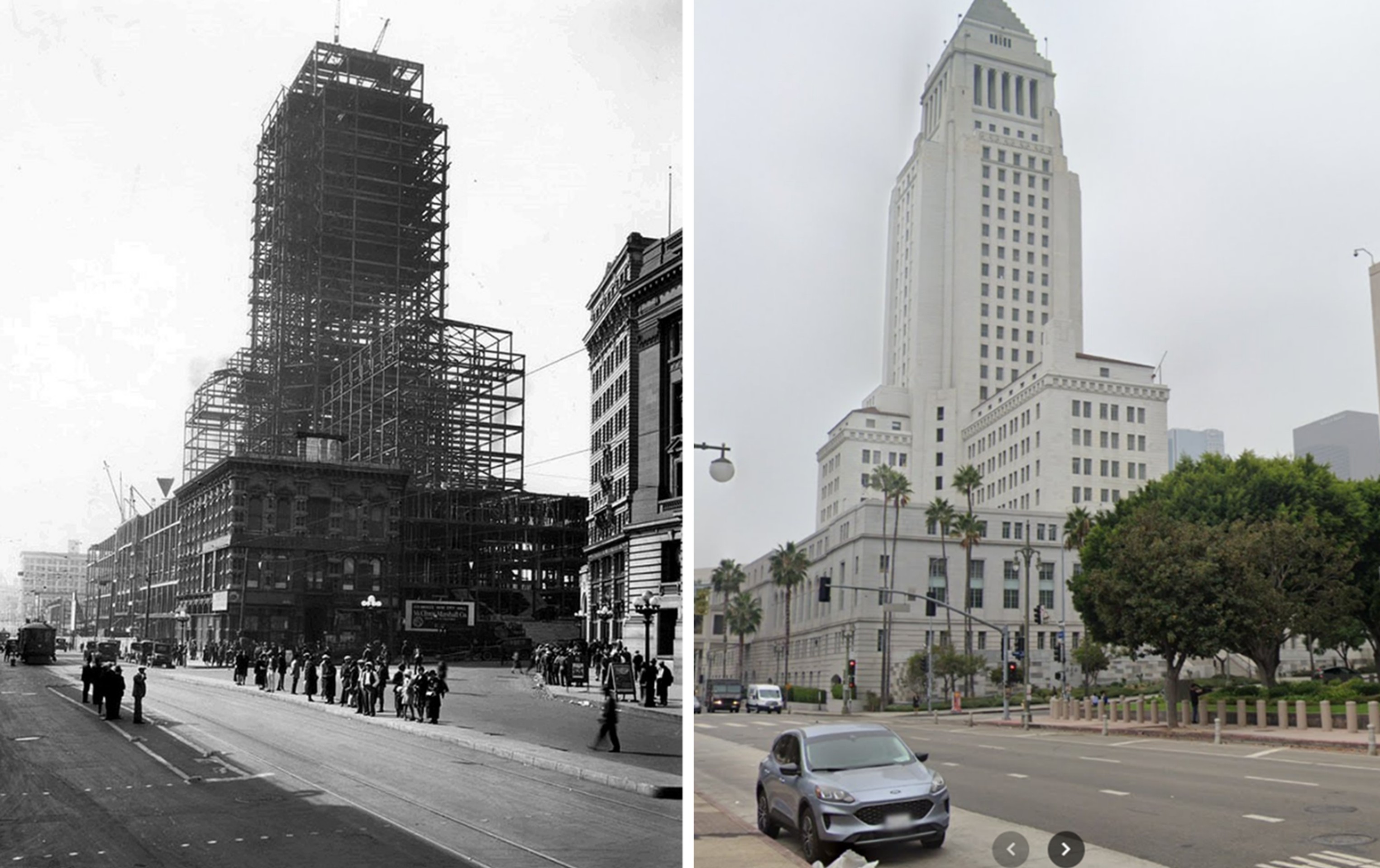
| (1927 vs. 2024)* – Los Angeles City Hall, Then and Now - On the left: City Hall under construction, rising from the cleared site of the historic Temple Block. On the right: the same view today, nearly a century later, with the completed 454-foot landmark still presiding over downtown. This rare 1927 image is one of the final glimpses of Temple Block before it vanished into history. Photo comparison by Jack Feldman. |
Then and Now
 |
|
| (1882 vs. 2024)* – Looking south on Main Street at Temple Street. Photo comparison by Jack Feldman. |
Historical Notes The 1882 photo captures daily life in early Los Angeles, with dirt roads, horse-drawn carriages, and the ornate Temple Block on the right—home to the Adolph Portugal store and a key commercial hub. Today, the view shows Los Angeles City Hall standing on the former site of the Temple Block. City Hall East appears on the left, connected by a pedestrian bridge across Main Street. |
* * * * * |
Temple and Hill Streets
 |
|
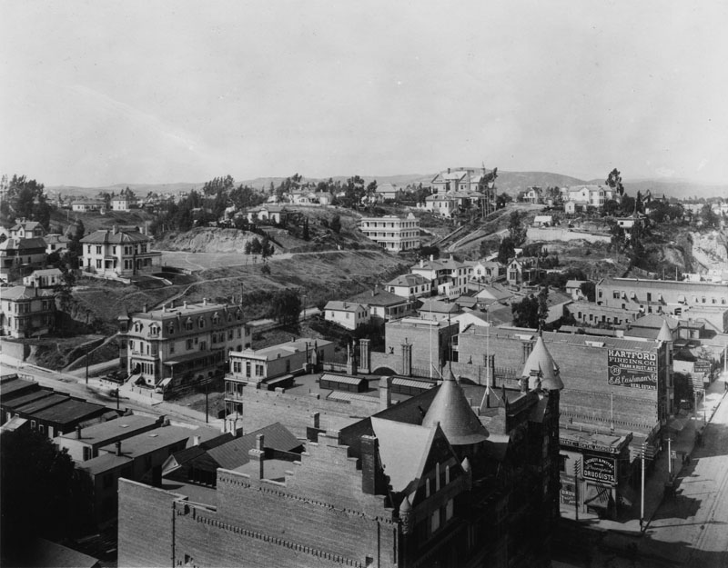
| (ca. 1884)* - View looking north at the intersection of Hill and Temple streets in downtown Los Angeles. Past Temple St. stands Fort Moore Hill, one of downtown L.A.’s “lost hills.” The Banning Mansion near the summit of Fort Moore Hill can be seen in the distance. |
Historical Notes Originally housing Fort Moore, one of two historic U.S. Military forts in Los Angeles during the Mexican-American War, the site was constructed in 1847, abandoned in 1849, and decommissioned in 1853. In 1882, Jacob Philippi purchased land on Fort Moore Hill, establishing a beer garden which became a popular local attraction. He later sold the property to Mary Banning, who converted it into the impressive 21-room Banning Mansion, a focal point of high society. The mansion, offering sweeping views of Los Angeles, eventually fell out of prominence as the city expanded. It was later converted into a rooming house before being demolished. Reflecting the city's rapid growth and changing social landscape, the site also became home to Los Angeles High School in 1891 and later the Los Angeles Unified School District headquarters. |
 |
|
| (1906)* - View looking north at the intersection of Hill Street and Temple twenty-two years later in 1906. The tall tower to the upper left is that of Los Angeles High School (2nd location) which was built in 1890. |
Historical Notes Los Angeles High School moved to Fort Moore Hill in 1891, occupying a site on North Hill Street between San Street and Bellevue Avenue. The high school remained there until 1917, after which the location became the headquarters for the Los Angeles Unified School District until 2001. In the early 20th century, much of Fort Moore Hill was removed for urban development, including the construction of the 101 Freeway. |
 |
|
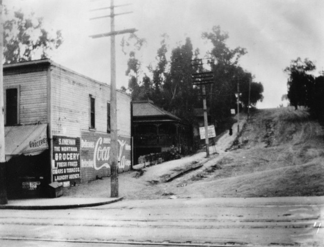
| (1908)* - Looking south at Hill Street from Temple before the Hill Street Tunnel was bored. The Montana Grocery (S. Kinderman, grocer) advertises fresh fruit, cigars & tobacco, laundry and "Delicious Coca-Cola." Streetcar tracks are visible in the foreground. |
Historical Notes The first Hill Street Tunnel, built by the Los Angeles-Pacific Railway and completed in 1909, served interurban rail cars and reduced travel times by 15 minutes. The second tunnel, built by the city for pedestrians and vehicles, opened in 1913. These 550-foot-long tunnels provided direct access to Sunset Boulevard, bypassing the steep grades of Bunker Hill and Fort Moore Hill. The northern portal of the Hill Street Tunnels was near Temple Street, while the southern portal was at First Street. |
Before and After
 |
|
| (1884 vs 1906) - Looking north at the intersection of Temple and Hill Street before and after the construction of Los Angeles High School. Photo comparison my Jack Feldman. |
 |
|
| (2022)* - Google Earth view looking north toward the intersection of North Hill and West Temple Street. Today, the 101 Freeway runs beneath Hill Street, visible at the center-top of the photo. |
Historical Notes Work on removing Fort Moore Hill began in 1949 to make way for the Hollywood Freeway, a major excavation project that reshaped the downtown landscape. As part of a larger freeway construction effort from 1947 to 1954, this project effectively obliterated most of the historic hill between Sunset Boulevard and Temple Street. The freeway was built in a trench through downtown Los Angeles, allowing it to pass under existing streets like Hill Street, thus preserving the street grid above. |
Then and Now
 |
|
| (1884 vs 2022) - A 'Then and Now' view using Google Earth, showing Hill Street looking north at Temple Street from a slightly different angle. Photo comparison by Jack Feldman. |
 |
|
| (2022)* - Contemporary view of Hill Street looking north at Temple Street. |
Then and Now
 |
|
| (1884 vs. 2022)* - A 'Then and Now' view of Hill Street looking north at Temple Street. This comparison gives a clearer picture of how Hill Street was partially straightened, and how both Fort Moore Hill (north of Temple) and Bunker Hill (south of Temple) were largely flattened. Photo comparison by Jack Feldman. |
* * * * * |
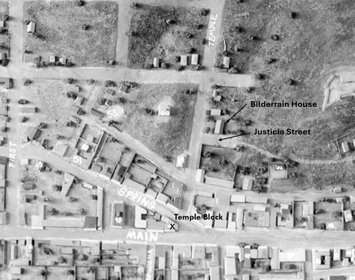
Temple and Justicia Street (Originally Buena Vista Street)
 |
|
| (ca.1870s)*- Model image depicting how downtown Los Angeles appeared in the mid to late 1800s. The T-intersection of Temple Street and Judicia Street is visible near the center, with the Bilderrain Adobe situated on the northwest corner. |
Historical Notes Justicia Street, an early north-south dirt road and thoroughfare in Los Angeles, underwent significant changes as the city developed. Originally running parallel to New High Street and ending near Temple Street, it served a modest residential area in the late 19th century. |
 |
|
| (ca. 1874)* - Looking west on Temple Street, with Los Angeles High School atop Poundcake Hill and St. Athanasius Episcopal Church visible in the center of the photo. The street that ends at Temple Street on the center-right is Justicia Street. The street in front of St. Athansius is New High Street (later Spring Street). The street behind the high school was Fort Street (later Broadway). |
Historical Notes Built in 1864, St. Athanasius was the first Episcopal church in the City of Los Angeles. It was situated on the northeast corner of Poundcake Hill at Temple and New High Streets (later Spring Street). Pouncake Hill will later be home to the Los Angeles Country Courthouse, completed in 1891. |
 |
|
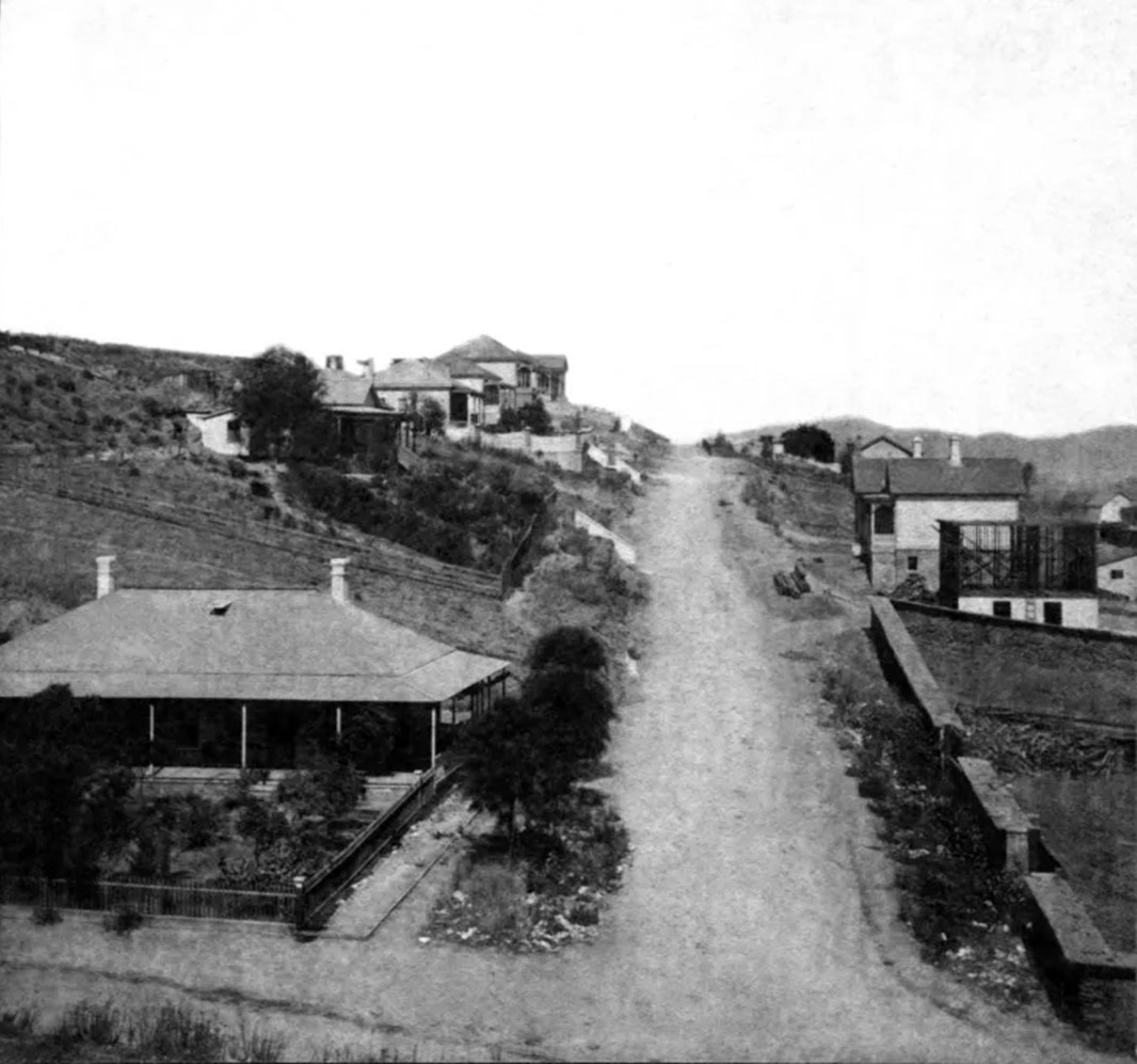
| (1880s)* – Looking north on Justicia Street (originall Buena Vista Street) at its intersection with Temple Street, with the Bilderrain Adobe visible on the northwest corner. |
Historical Notes The suburban-looking residence in the foreground is at the northwest corner of Temple and Justicia Streets. It served as the longtime family home of the Bilderrain family, whose presence in Los Angeles was established by Jose Ygnacio Bilderrain. He likely settled in L.A. between 1847—when he married in San Juan Capistrano—and 1850, as he appears in the 1850 L.A. census. His grandson, also named Jose Ygnacio Bilderrain, was wounded during the conflict that immediately preceded and sparked the Chinese Massacre of 1871. Several of the unfortunate Chinese victims were lynched on the gatepost of the lumber yard across Justicia Street from the Bilderrain home (the site is out of frame to the right and later hosted the Los Angeles County Jail). |
 |
|
| (ca. 1891)* - Looking south on Justicia Street toward its terminus at Temple Street, where the 1891-built Los Angeles County Courthouse stands. A horse-drawn carriage is parked in front of the Belderrain Adobe, located on the northwest corner. |
Historical Notes As late as 1928, Justicia Street was still a dirt road north of the section adjacent to the County Jail. |
 |
|
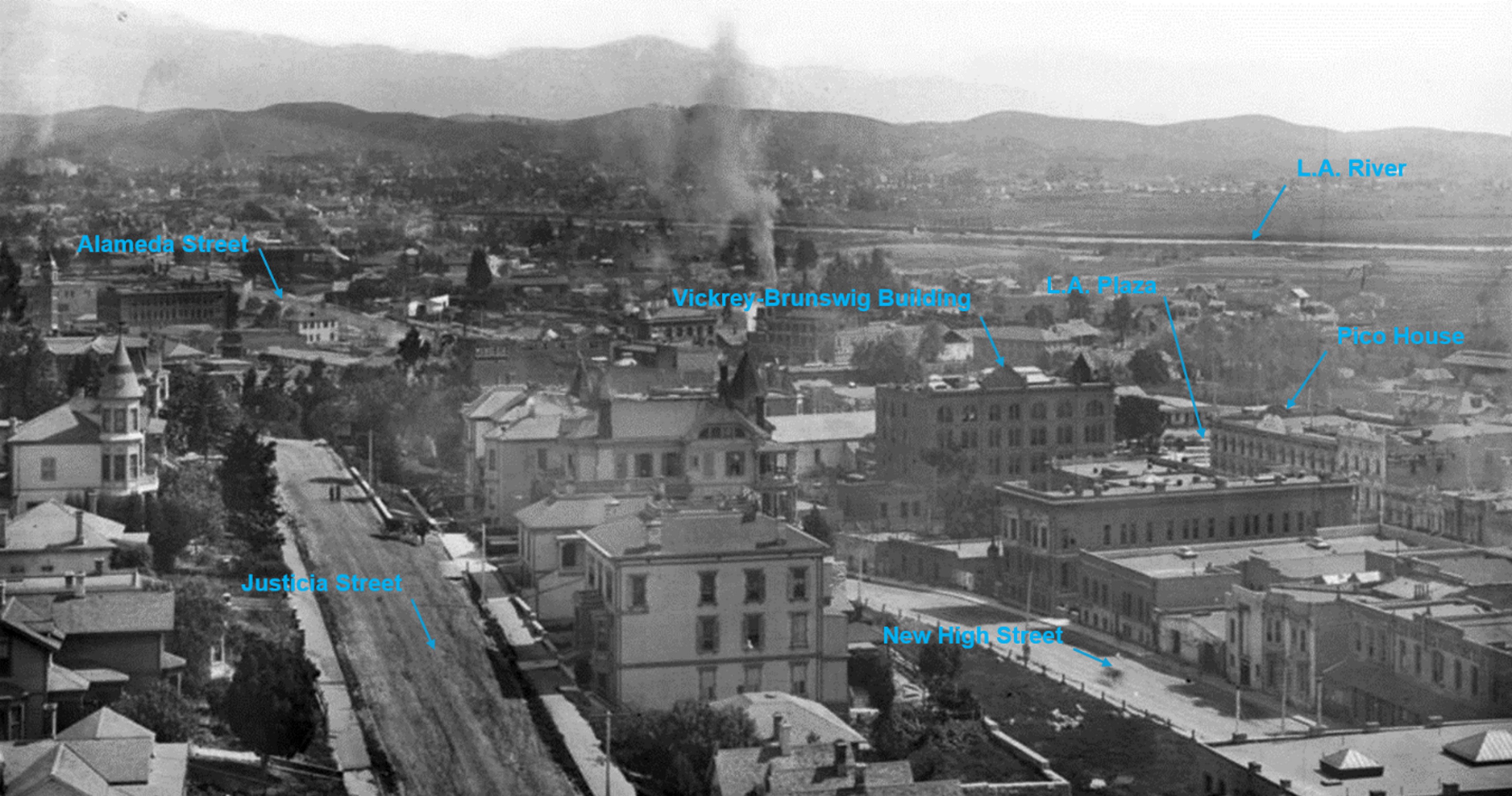
| (ca. 1889)* – Panoramic view looking northeast from the top of the Los Angeles County Courthouse, with Justicia Street (originally Buena Vista Street) visible on the left and New High Street on the right. The Los Angeles River can be seen in the distance. |
Historical Notes Note how full the Los Angeles River is—it’s rare to see it like this unless right after a storm. |
 |
|
| (ca. 1889)* - Panoramic view looking northeast from the top of the Los Angeles County Courthouse, annotated to provide better reference points. Justicia Street is visible on the left, and New High Street is on the right. The L.A. Plaza area is also on the right, with a fairly full Los Angeles River visible further back in the distance. |
Historical Notes Justicia Street played a significant role in early Los Angeles history, hosting prominent families like the Bilderrains who settled there around 1850. The street was also the site of tragic events, including part of the Chinese Massacre of 1871. Despite its importance, parts of Justicia Street remained unpaved as late as 1928, particularly north of the County Jail. The street's eventual fate was likely sealed by the extensive redevelopment of downtown Los Angeles in the early to mid-20th century. During this period of urban transformation, many older streets and buildings were demolished or altered to accommodate newer developments, especially government buildings in the emerging Civic Center area. This redevelopment led to the disappearance of Justicia Street. New High Street was significantly altered during the 1920s redevelopment of downtown Los Angeles. The construction of City Hall in 1928 and the realignment of Spring Street led to the removal of New High Street's southern portion, particularly around Temple Street. This resulted in a much shorter New High Street, with its southern end effectively pruned back. These changes were part of the broader transformation of downtown Los Angeles, which included the development of the Civic Center district and alterations to the existing street grid. |
 |
|
| (ca. 1886)* - Early map showing Buena Vista Street, where Justicia Street was previously identified. This map suggests that Justicia Street was originally named Buena Vista Street. The exact year of the name change remains undetermined. |
 |
|
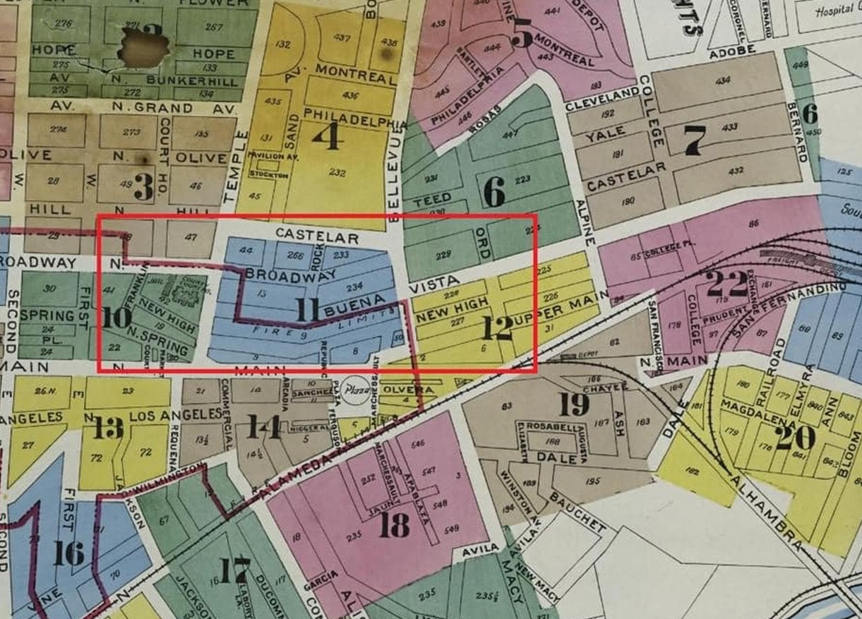
| (1920s)* - Map showing the fragmented configuration of streets near Temple and Justicia Streets. |
Historical Notes The area bordered by Main St., Broadway, Temple St., and First St. has a complex street layout due to the original, somewhat disorganized design and the renaming and removal of some streets in the late 1920s. As a result, even longtime residents may not recognize older names like “Jail St.” or “Pound Cake Hill” when looking at maps from 1900 to 1920. |
 |
|
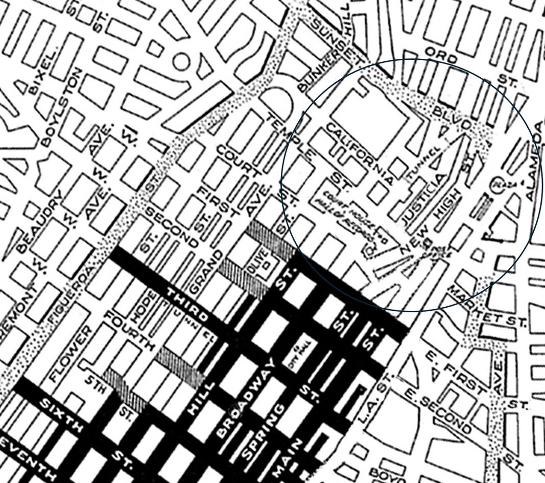
| (1930)* - View looking north, showing the proposed Spring Street extension that will cut through from Temple Street to Sunset Boulevard, creating a new traffic artery. The dotted lines indicate the path of the extension, which will eliminate Justicia Street as it ascends the hill on the left. The first building intersected by the dotted lines is the old county jail, with the old Hall of Justice just behind it. The building on the left is the Old County Courthouse. |
Historical Notes Justicia Street was eliminated during the extensive redevelopment of downtown Los Angeles in the early to mid-20th century, which coincided with the construction of the current City Hall completed in 1928. This period also saw the realignment and extension of Spring Street, along with the demolition and alteration of many older streets and buildings to accommodate new government structures in the Civic Center district. |
* * * * * |
Bellevue Avenue and Buena Vista Street (later Sunset Boulevard and Justicia Street)
 |
|
| (1870s)* - View looking north from the edge of Fort Moore Hill along Buena Vista Street (later Justicia Street) toward Bellevue Avenue (later Sunset Boulevard), where it continues as Eternity Street (now North Broadway) in Sonora Town. |
Historical Notes In 1884, Eternity Street was renamed Buena Vista Street. In 1909, Buena Vista Street became North Broadway. Bellevue Avenue became Sunset Boulevard in the ealy 1900s (before 1924). Sunset Boulevard was officially renamed Cesar Chavez Avenue in 1994. |
 |
|
| (1871)^ - View looking northeast from General Phineas Banning's residence on Fort Hill toward the intersection of Buena Vista Street and Bellevue Avenue (later Sunset). North of Bellevue, Buena Vista would later become North Broadway, while south of Bellevue, it would be named Justicia Street. Beyond the intersection lies Sonora Town, with the Southern Pacific Railroad shops visible in the distance. |
Historical Notes Buena Vista Street, south of Bellevue Avenue (later Sunset Boulevard), was renamed Justicia Street. After the Broadway Tunnel was built in 1901, Broadway extended under Fort Hill and merged with Justicia Street near Sunset Boulevard, continuing north as North Broadway. Justicia Street ran from Temple Street—located one block east of Broadway—over Fort Hill and merged with Broadway as it exited the tunnel at Sunset. |
 |
|
| (1885)* - Looking southwest toward Fort Hill from the intersection of Bellevue Avenue and Buena Vista Street (later Sunset Boulevard and Justicia Street). The Banning House can be seen at the top of the hill. |
Historical Notes Buena Vista, south of Bellevue Avenue (later Sunset Boulevard), was renamed Justicia Street. When the Broadway Tunnel was built in 1901, the road split: one branch continued east over Fort Hill as Justicia Street, while the tunnel route was renamed North Broadway. |
 |
|
| (1929)* - Southwest corner of North Broadway and Sunset Boulevard, showing the north portal of the Broadway Tunnel, which later was demolished, the hill removed and the street widened. The newly constructed City Hall (1928) can be seen in the background. |
Historical Notes The road running up the hill on the left is Justicia Street, which extended south to Temple Street, ending in front of the Los Angeles County Courthouse between Broadway and Spring Streets. It was one of the last dirt roads in downtown Los Angeles. Click HERE to see more of the intersection of Justica Street and Sunset Boulevard. |
* * * * * |
Temple Block
 |
|
| (1885)^ - View showing the Temple Block with clock-tower, home of the Los Angeles County Courthouse. Further back are two three-story Victorian-style buildings: the Amestoy Building and the United States Hotel located at the intersection of Main Street and Requena Street (later Market Street). The intersection of Market and Spring streets is at lower left. |
Historical Notes Jonathan Temple, a merchant from Massachusetts, played a crucial role in shaping Los Angeles by establishing the Temple Block in 1828. He started with a general store at Main and Spring Streets, turning the area, known as Temple Square, into the city's commercial hub. In 1848, Temple built a two-story adobe building on the block, and over the following decade, he expanded it with additional structures, including a two-story brick building in 1857, marking a shift from adobe to brick construction. As a pioneer in urban development, Temple introduced paved sidewalks and street trees to improve the area's attractiveness. In 1871, he replaced the adobe building with a three-story Italianate structure called the New Temple Block, which accommodated retailers and offices. Although the Temple Block faced economic difficulties due to the end of the Gold Rush and a national depression in the late 1850s, it remained a significant business center until the early 20th century. By the mid-1920s, the area was redeveloped for a new Civic Center, leading to the demolition of the Temple Block and the completion of the Los Angeles City Hall on the site in 1928. |
 |
|
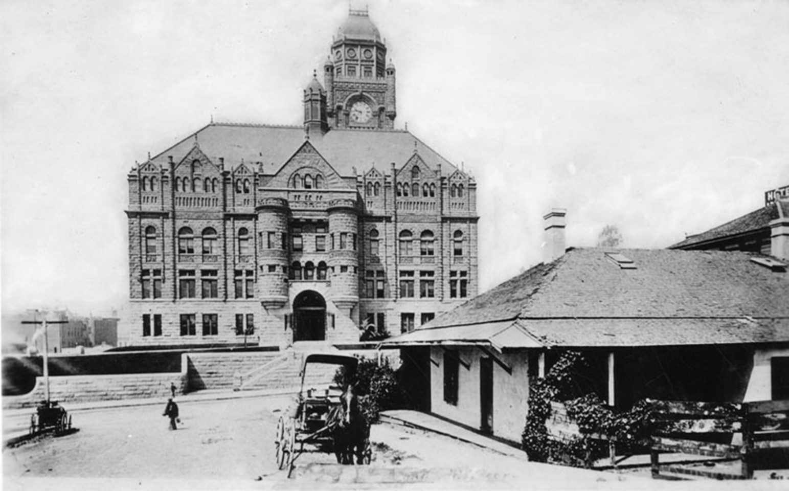
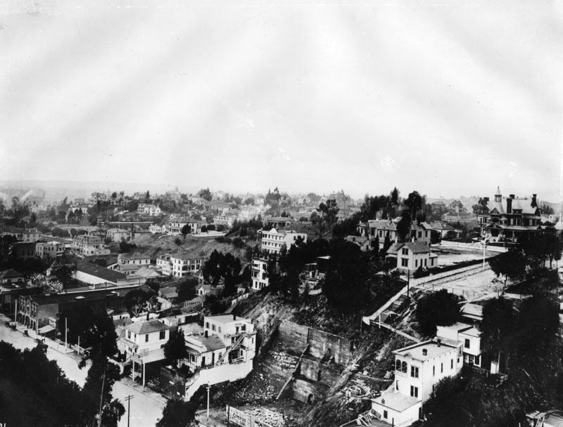
| (1880s)* – View looking northeast showing the Los Angeles County Courthouse with its clock tower. The corner of the courthouse closest to the camera is on the southwest corner of Spring and Court streets. |
Historical Notes Los Angeles County Courthouse was originally located at the Plaza in the old pueblo, but later it moved to the Temple Building, part of the Temple Block complex constructed by Jonathan Temple. This building, one of the earliest significant structures in the growing city, served as the courthouse around 1880. This period was crucial for Los Angeles as it transitioned from a small pueblo to a burgeoning American city. The Temple Building thus played an important role in the city's legal and civic development during this transformative era. |
 |
|
| (1891)* – View looking toward the Temple Block from Spring Street with Court Street on the right and Market Street at left. Main Street can be seen in the distance on the right. |
 |
|
| (1891)* – Blow-up view of previous photo showing Court Street looking east toward Main Street as seen from Spring Street. A young man is seen on a donkey in the middle of the street while several horse-drawn wagons are parked along the curb. |
 |
|
| (ca. 1891)* - View of Market Street looking west from the cupola of the United States Hotel, soon after the construction of the New Courthouse on Poundcake Hill (background). The old market and Courthouse of Temple Block can be seen at left. |
Historical Notes On the north side of Market was the south portion of the Temple Block; on the south side was the original market building erected in 1859 by John Temple, which later became a County Courthouse (LA's 5th). The Bullard Block (Building) would replace the old Clocktower County Courthouse (NE corner of Spring and Court streets) in the late 1890s. Today, City Hall stands at this location. |
Click HERE to see 'From Temple Block to City Hall' |
* * * * * |
Spring and 1st Street
 |
|
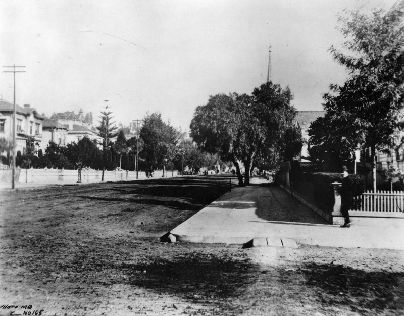
| (ca. 1885)^ - Showing what was primarily a residential area at the time is the Schumacher residence located on Spring and 1st Streets. This would later be the site of the current LA Times Building. |
Historical Notes John Schumacher was a German immigrant who became a wealthy landowner in Los Angeles and was a member of the city's governing council. He settled in Los Angeles in 1847, but in 1849 Schumacher went to Sutter's Creek, where he found a nugget of gold worth eight hundred dollars. He then bought nearly the whole block bounded by Spring and First streets and Franklin Alley for the value of his famous gold nugget. |
* * * * * |
Fort Street (later Broadway) and 3rd Street
 |
|
| (ca. 1882)* - View looking north on Fort Street (later Broadway) from Third Street. The spire of the First Presbyterian Church can be seen above the trees at right. |
Historical Notes Fort Street in Los Angeles, laid out by surveyor Edward O. C. Ord in 1849, was named after Fort Moore, a strategic military site from the Mexican-American War that overlooked the city. By the late 1880s, the city's increasing population of German immigrants found it difficult to distinguish between "Fort Street" and "Fourth Street," causing confusion, particularly with the primitive telephone systems of the time. As Fort Street transitioned from a residential area to a retail district, this confusion became a significant issue. To address this, a group of residents and merchants, led by printer Fred Lind Alles, petitioned for a name change. They chose "Broadway" to project a sense of future growth and emulate the prestige of New York City's famous thoroughfare. The Los Angeles City Council approved the name change on February 17, 1890, and it was signed into ordinance by Mayor Henry Hazard two days later. |
 |
|
| (1886)^ - View looking north on Fort Street (later Broadway) from 3rd Street. The streets are unpaved and appear to be residential. The tall spire in the distance is the First Presbyterian Church on the southeast corner of Fort and 2nd Streets. LA's 3rd City Hall would be built on this block in 1888 on the east side of Broadway between 2nd and 3rd streets. Over the course of the next several years the west side of the street would also be built up with commercial buildings. |
Historical Notes Following the renaming, Broadway swiftly emerged as the epicenter of Los Angeles' commercial and entertainment scenes. The segment between 3rd and 9th Streets became particularly renowned for its dense array of theaters and commercial establishments. This area, recognized as the Broadway Theater and Commercial District, is listed on the National Register of Historic Places and boasts the largest collection of historic movie palaces in the United States. |
Then and Now
 |
|
| (1886 vs 2024)* - Looking north on Fort Street (today Broadway) at 3rd Street. Photo Comparison by Jack Feldman. |
* * * * * |
Broadway and 2nd Street
 |
|
| (ca. 1887)^ - View looking northwest from the top of City Hall (under construction - completed in 1888) on Broadway. The intersection of 2nd and Broadway is at lower-right where the California Bank Building stands on the southwest corner. The 3-story white building with the balconies (top-center) is the Highland Villa (n/w corner of 1st and Hill). |
 |
|
| (ca. 1890)* - View looking west on 2nd Street at Broadway. Three women are seen walking by the front of the California Bank Building on the southwest corner with horse-drawn carriages parked at the curb. Photo by William H. Feltcher. |
Historical Notes The tracks running down second streets belong to the Second Street Cable Railway, first cable car system to open in Los Angeles (1885). |
Then and Now
.jpg) |
|
| (1890 vs 2022)* - Looking west on 2nd Street at Broadway toward Bunker Hill. In early photo, the ornate building on the SW corner with horse-drawn wagon parked in front is the 1887-built California Bank Building. You can see the tracks of the Second Street Cable Railway, first cable car system to open in Los Angeles (1885), that took passengers up and over Bunker Hill. The current phot shows the Second Street Tunnel that was bored under Bunker Hill between 1916 and 1921. Photo comparison by Jack Feldman. |
Historical Notes Click HERE to see more Early Views of the intersection of Broadway and 2nd Street. |
 |
|
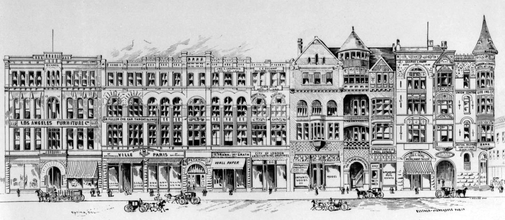
| (ca. 1890s)^^*- Photograph of an artist's rendering of a portion of a block on the west side of Broadway, between Second and Third Streets, showing commerical buildings and pedestrian traffic. The YMCA Building is the second building from the right. On the southwest corner of Broadway and 2nd Street, next to the YMCA, stands the California Bank Building. On the other side of Broadway are: City Hall , B'nai B'rith Temple, and the First Presbyterian Church. |
Historical Notes A block of commercial buildings, designed in the Second Empire style of architecture, is depicted in detail, with the row of buildings crossing the center of the image. Each building is four stories tall and its front contains many windows; the building at the right edge of the picture is more ornate, with gabled windows and a turret at its outer edge. The bulidings are fronted by a paved sidewalk, which is occupied by pedestrian traffic. The edge of another block can be seen at the rightmost edge of the image, while horse-drawn carriages line Broadway. Legible signs, from left to right, include: "Los Angeles Furniture Co", "Dr. Fuller Eye, Ear, Throat & Lungs", "Ville de Paris", "Jno.S Chapman. Atty. At Law", "T. Frank McGrath Wallpaper", "C.E. Decamp Builders Indemnity Co", "Lynn Helm Atty. At Law", "Pacific Coast Home Supply Association", "City of London Lace Curtains, Draperies", "Green & Willis Embroideries Laces Etc. Infant Goods. Modes", "Young Mens Christian Assn", "W.M.Gar & Co. Real Estate", "George S. Hupp Atty At Law", "Otto C. Sens Merchant Tailor", "Cal-Bank Building", "Gordon & Conrey Atty At Law", "Union Central Life Ins. Co", "Mutual Reserve Fund Life Assn of New York", and "Bank". |
 |
|
| (ca. 1889)^^- View looking at the SW corner of Broadway and 2nd Street showing the California Bank, the YMCA and in the distance (lower-left) can be seen the Fort Street Methodist Episcopal Church. Note: Broadway was known as 'Fort Street' until 1890. |
 |
|
| (1889)* – View looking south on Broadway at 2nd Street showing the California Bank Building on the southwest corner. City Hall (built in 1888) is across Broadway out of view on the left. In the distance (on the left) can be seen the Fort Street Methodist Episcopal Church |
* * * * * |
Bunker Hill
 |
|
| (ca. 1886)^ - Panoramic view of Bunker Hill, showing various public buildings and private residences, including the Bradbury Mansion on the far right. The three-story Highland Villa is seen at center (white building). Broadway runs diagonally south(left)/north in the lower left quadrant of the photo. The steep slope with the stairs next to it is the future site of Court Flight, Angels Flight's sister funicular railway. Court St. dead ends at the top of the slope. The Bradbury mansion (built 1886, demolished 1928) is the large house on top of the hill, facing east on to N. Hill St. The house directly across from it (partially hidden by trees), at 138 N. Hill, is the third Los Angeles home (built circa 1881, demolished 1955) of Sarah Bixby Smith, author of "Adobe Days" (1931). The Hill Street Tunnel was put through in 1908 after 1st St. was extended to the west. Court Hill (between Bunker Hill and Poundcake Hill) was removed entirely in the mid- to late 1950s. |
Historical Notes In 1867, a wealthy developer, Prudent Beaudry, purchased a majority of the hill's land. Because of the hill's excellent views of the Los Angeles Basin and the Los Angeles River, he knew that it would make for an opulent subdivision. He developed the peak of Bunker Hill with lavish two-story Victorian houses that became famous as homes for the upper-class residents of Los Angeles. Angels Flight (built in 1901), now dubbed "The World's Shortest Railway", took residents homeward from the bottom of the 33% grade and down again. Prudent Beaudry served as the 13th Mayor of Los Angeles, California from 1874 to 1876. Beaudry Avenue was named after him. |
 |
|
| (ca. 1895)^^ - View of Bunker Hill from the Court House roof. The Court Street cul de sac is seen (before the installation of Court Flight). Bradbury Mansion is shown at the intersection of Hill and Court Streets. The Bixby house (two story directly across Hill St. from Bradbury) appears at the center of frame. |
 |
|
| (1899)* - Similar view of Bunker Hill as previous two photos but several years later. Note the new buildings on Broadway in the foreground. |
Historical Notes The steep slope with the stairs next to it is the future site of Court Flight (1905), Angels Flight's sister funicular railway. Court St. dead ends at the top of the slope. |
 |
|
| (ca. 1900)^^ - Closer view of Bunker Hill showing the staricase leading up to the end of Court Street. The magnificent Bradbury Mansion sits on top of the hill as well as Sarah BixbySmith's home across the street (left of photo). |
Historical Notes After Lewis Bradbury's widow moved out of the Bradbury Mansion, it was used as a club for judges, then as the Rollin Film Studio and finally, as a rooming house before being demolished in 1928. |
* * * * * |
3rd Street and Broadway
 |
|
| (1888)* - Looking west on an unpaved 3rd Street toward Broadway, you can see the Crocker Mansion atop Bunker Hill in the distance. The steeple of the First Congregational Church on the northeast corner of 3rd and Hill Street is also visible. The Bradbury Building would later be constructed on the southeast corner of 3rd and Broadway in 1893. Photo by C.C. Pierce |
 |
|
| (2024)* - Looking west on 3rd Street toward Broadway with the Bradbury Building seen on the left (Southeast corner). |
Then and Now
 |
|
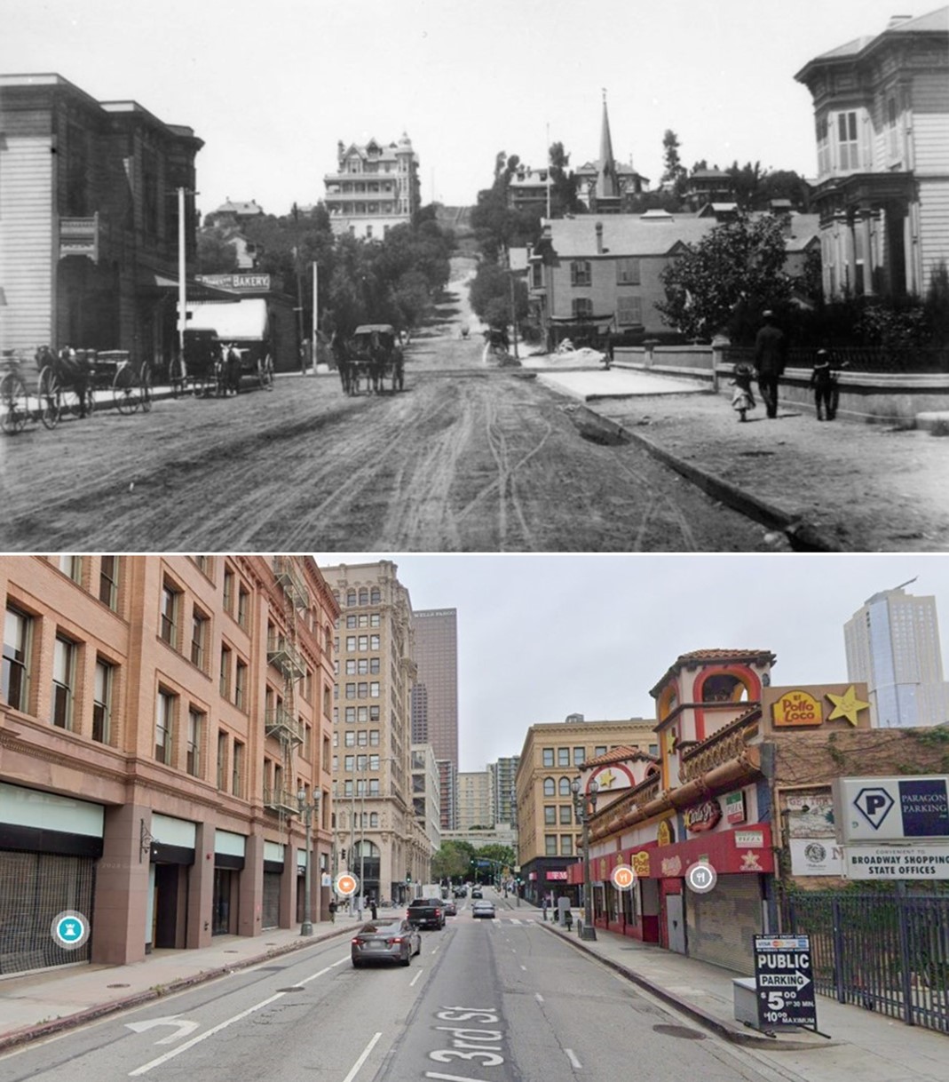
| (1888 vs 2024)* - Looking west on 3rd Street toward Broadway in downtown Los Angeles. In the older image, you can see the Crocker Mansion atop Bunker Hill in the distance, and the steeple of the First Congregational Church on the northeast corner of 3rd and Hill Street. In the contemporary photo, the Bradbury Building, built in 1893, is visible on the left (southeast corner). Photo comparison by Jack Feldman. |
* * * * * |
Hill and 3rd Streets
 |
|
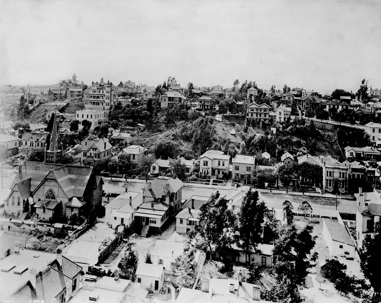
| (ca. 1888)* - Panoramic view looking west toward Bunker Hill, showing Hill Street between 2nd and 3rd Streets as seen from the tower of the 1888 Los Angeles City Hall at 228 S. Broadway. Visible landmarks include the First Congregational Church on the northeast corner of Hill and 3rd, and the 3-story Victorian Crocker Mansion perched atop Bunker Hill, both seen on the left. Photo by C. C. Pierce. |
Historical Notes In 1888, the intersection of Hill and 3rd Street in downtown Los Angeles was part of the prestigious Bunker Hill neighborhood. This area, developed in the 1870s by Prudent Beaudry, had become an upscale residential district featuring grand Victorian mansions and luxury hotels. The south side of 3rd Street and the west side of Hill Street were lined with impressive Queen Anne-style houses, offering panoramic views of the rapidly expanding city below. At this time, 3rd Street steeply ascended Bunker Hill, as the 3rd Street Tunnel had not yet been constructed. |
 |
|
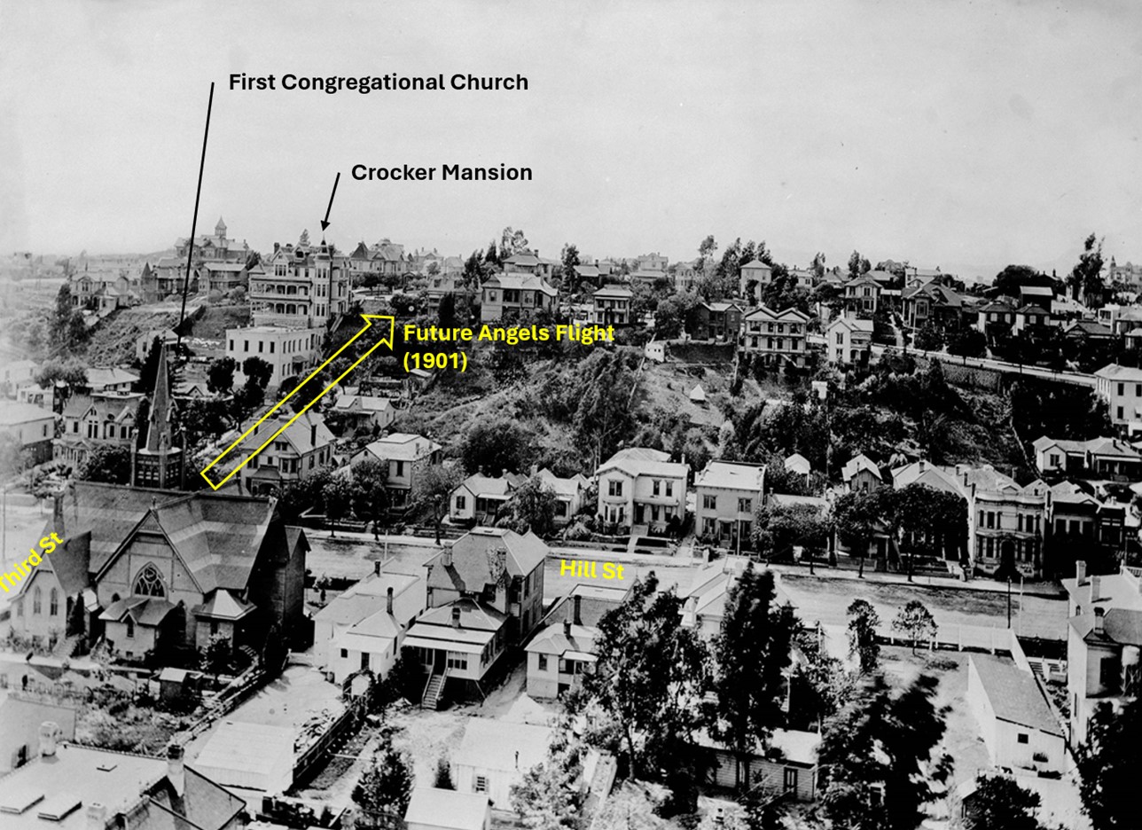
| (ca. 1888)* - Panoramic view looking west toward Bunker Hill, showing Hill Street between 2nd and 3rd Streets as seen from the tower of the 1888 Los Angeles City Hall at 228 S. Broadway. Visible landmarks include the First Congregational Church on the northeast corner of Hill and 3rd and the 3-story Victorian Crocker Mansion perched atop Bunker Hill. Also highlighted is the future site of Angels Flight, built in 1901, with the adjacent Third Street Tunnel completed beneath Bunker Hill that same year. Photo by C. C. Pierce. Annotated by Jack Feldman. |
Historical Notes The Third Street Tunnel and Angels Flight were two pivotal transportation features that would transform downtown Los Angeles. The Third Street Tunnel, constructed between 1899 and 1901, stretched 1,240 feet through Bunker Hill, connecting downtown to the developing western areas of the city. Despite facing numerous challenges during construction, including cave-ins and water seepage, the tunnel opened to the public in March 1901. That same year, Angels Flight, a funicular railway, began operation nearby, linking the downtown commercial district with the upscale residential area atop Bunker Hill. |
 |
|
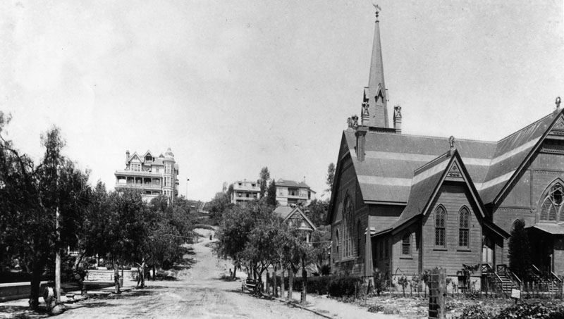
| (ca. 1885)^ - View looking west on 3rd Street toward Hill Street with Bunker Hill and Crocker Mansion in the background. On the right is the First Congregational Church on the northeast corner. It later became the Central Baptist Church and then the Unitarian Church. |
Historical Notes At the turn of the 20th Century, no building dominated Bunker Hill like the Crocker Mansion. Perched high at the corner of Third and Olive, the imposing 3-story Victorian structure overlooked the emerging metropolis for more than 22 years. |
 |
|
| (ca. 1885)* - View of Bunker Hill, looking west on 3rd St. toward Hill St. On the right is a closer look at the First Congregational Church, built in 1883. The Crocker Mansion, located at 3rd and Olive, was later called the Crocker Mansion Rooming House became the site of the Elks Club (later the Moose Lodge). |
Historical Notes By 1901, city and private engineers would come up with two different ways to traverse the steep hill...they built an 1080-foot long tunnel and a 33-percent grade funicular at the intersection seen above. |
 |
|
| (1886)^ - View of Bunker Hill from Hill and 3rd looking northwest. The Crocker Mansion, located at 3rd and Olive, can clearly be seen at the top of the hill. |
 |
|
| (ca. 1990)* - The Crocker Mansion (upper center, 300 South Olive Street, later BPOE Temple), viewed from the corner of Third Street and Hill Street in Bunker Hill. The image showcases the Queen Anne style house on the upper part of the hill, featuring a multi-windowed corner tower, verandas, a balcony set into the roof, and an English chimney. In the foreground, there is a lawn with a Fan Palm tree and an unidentified Victorian house. Photo by C. C. Pierce. |
Historical Notes The Crocker Mansion, located at 300 South Olive Street, was one of the most notable residences in Bunker Hill. Built in 1886 by Margaret E. Crocker, the widow of California Supreme Court Justice Edwin Bryant Crocker, the mansion was an imposing three-story Victorian structure designed by architect John Hall. Margaret Crocker was a prominent social and civic leader, known for her philanthropy, including the donation of the family's art collection to the city of Sacramento. The mansion's history is marked by both grandeur and scandal. In 1887, it became the center of a high-profile kidnapping case when Margaret Crocker's granddaughter, Alma Ashe, was taken by her father, Robert Porter Ashe, amidst a contentious divorce. Despite such dramatic events, the mansion remained a symbol of elite society in Los Angeles. In 1891, the Crocker Mansion was converted into a boarding house, which was still considered more luxurious than the typical rooming houses on Bunker Hill at the time. However, the construction of the Third Street Tunnel in 1900 compromised the mansion's structural integrity, leading to its eventual demolition in 1908 to make way for new development. |
 |
|
| (1895)* – View looking west at 3rd and Hill Streets with the Crocker Mansion seen at the top of Bunker Hill. The southwest corner of 3rd and Hill (lower-right) would become the lower station terminal of Angels Flight. |
* * * * * |
Angels Flight and the 3rd Street Tunnel
 |
|
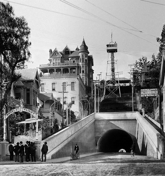
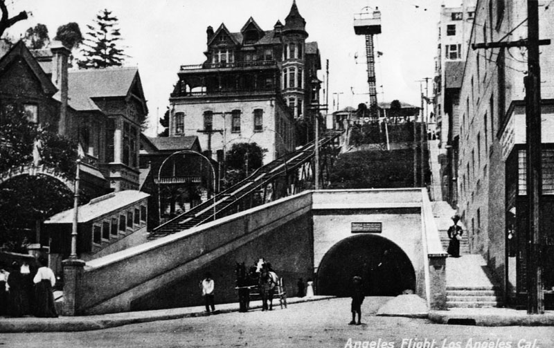
| (1901)^*# - Photo of Angels Flight at the grand opening of the railway, December 31st, 1901. An observation tower was also constructed on top of the hill adjacent to the Crocker Mansion. Third Street Tunnel was also opened in 1901. |
Historical Notes Built in 1901 with financing from Colonel J.W. Eddy, as the Los Angeles Incline Railway, Angels Flight began at the west corner of Hill Street at Third and ran for two blocks uphill (northwestward) to its Olive Street terminus.^* Click HERE to see more Early Views of Angels Flight. On July 3, 1893, residents and taxpayers presented a petition to the Los Angeles City Council asking that a tunnel be created to connect those who lived in the Crown Hill neighborhood with the business district located on this side of Bunker Hill. Their plans called for a tunnel 1080 feet long, with a twenty-six foot roadway and eight foot sidewalks. Nothing happened for five years. But work finally started and by March of 1901 the tunnel was opened to the public. It was unpaved and unlit. Gutters weren’t installed until 1902. Click HERE to see more Early Views of the Third Street Tunnel. |
Before and After
|
||
 |
||
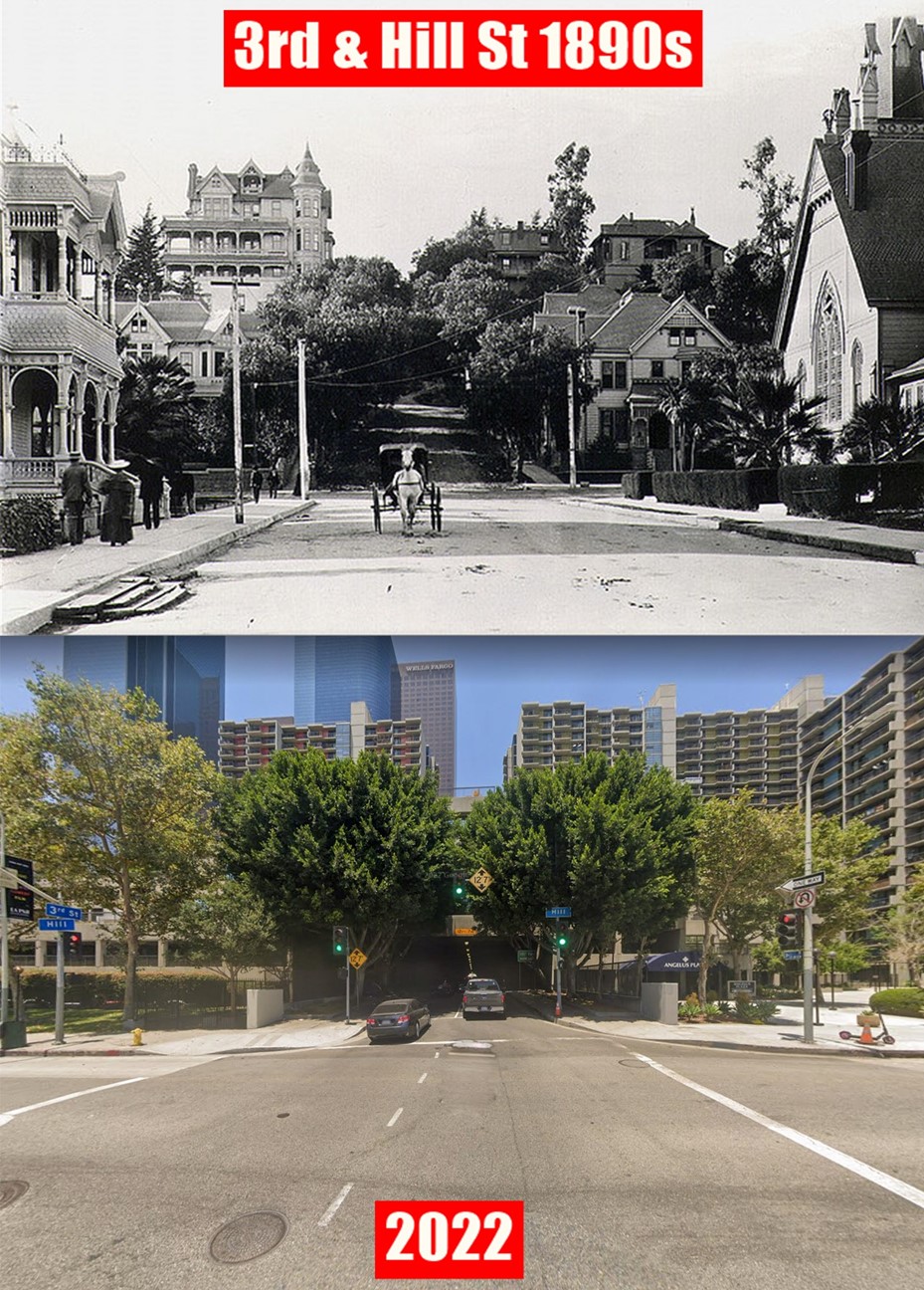
| (1885 vs 1903) - View looking west on 3rd Street near Hill Street. Photo comparison by Jack Feldman. |
Then and Now
 |
|
| (Then and Now)* – View looking west at 3rd Street at Hill Street. |
* * * * * |
Temple Street (w/o Bunker Hill)
.jpg) |
|
| (1876)^ - View of an unpaved Temple Street looking west from Bunker Hill, with various houses visible there and on the hill in the background. Court Circle, as laid out, is at the left. Temple Street curves, following the contour of the land. |
 |
|
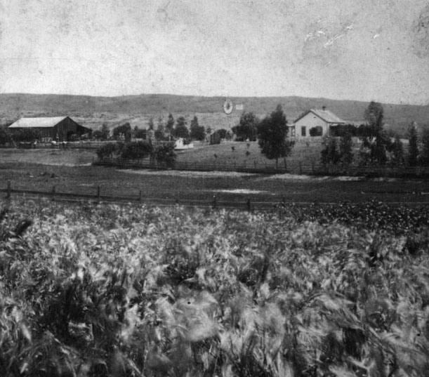
| (1870s)^ - View of a field of wheat growing on a ranch in the vicinity of Temple Street and north Vermont Avenue. A house, farm buildings and a windmill are seen. |
* * * * * |
Victor Heights
 |
|
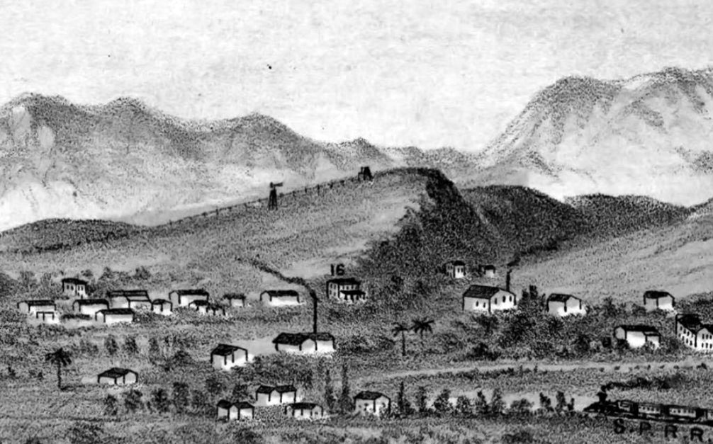
| (1877)^^ - Detail of E.S. Glover’s View of Los Angeles from the East showing what was to become Victor Heights. |
Historical Notes Canadian brothers Prudent and Victor Beaudry first increased their fortunes (having been born wealthy) in Northern California with a variety of business pursuits before moving to Los Angeles where Prudent entered politics (from 1874 to 1876 he served as Los Angeles’s thirteenth mayor). Victor mined, developed water works, and worked in real estate before moving to Los Angeles in 1855. He and his mining partner (and fellow Quebecois) Damien Marchessault built an ice house in Los Angeles in 1859 — the year Marchessault became mayor — and sold ice to saloon keepers and others. In the 1860s, the Beaudrys bought land in and around the French Town section — an historic neighborhood centered around Alameda and Aliso streets whose existence today is mainly seen in street names like Bauchet, Ducommun, and Vignes. Beaudry went on to increase his fortunes in silver mines and simultaneously earned the nickname the “water king” as he developed water transportation systems for both mines and in town. After the mines began to prove less profitable, Victor moved to Montreal in 1876 where he married Angelica Le Blanc. The couple and their family moved back to Los Angeles in 1881 where he remained until 1886. In Los Angeles, the Beaudry brothers built a water reservoir in the Elysian Hills and used it to hydrate their properties there including Bunker Hill (subdivided in 1876), and what would become Angeleno Heights and Victor Heights. To make their properties more appealing to potential homebuyers, the Beaudrys created two parks, Bellevue Terrace and Beaudry Park. Beaudry Park was a 7.4 acre oval property designed by landscape architect/gardener Francis Tamiet and included many Mexican limes, gums, cypresses, oranges, and Monterey pines.* Ultimately, the Beaudrys placed their two gardens on the market soon after they liquidated the surrounding real estate tracts. In 1881 the state purchased Bellevue Terrace for the site of the California Branch State Normal School, a teaching college that eventually became UCLA. When the Los Angeles Central Library replaced the college in 1926, construction crews graded the hill out of existence. Beaudry's Park, meanwhile, was purchased in 1883 by the Sisters of Charity. On that site (now occupied by The Elysian apartment building and Holy Hill Community Church) the sisters placed their new infirmary, repurposing Beaudry's fruit trees and cypresses into a soothing backdrop for their patients. |
 |
|
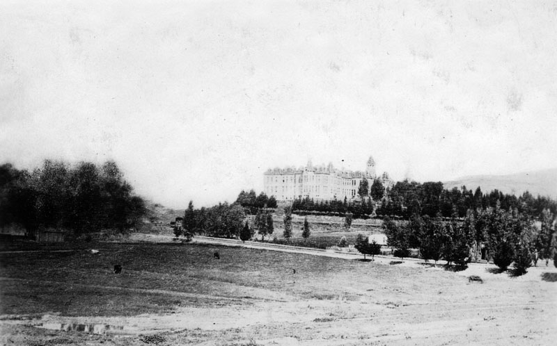
| (ca. 1887)* - View looking northwest showing St. Vincent's Infirmary (aka Sisters Hospital) located near Sunset Blvd and Beaudry Ave as seen from across a sparse field. Several trees can be seen to the right of the grand hospital, which boasts of numerous windows, dormers, an irregular roof, a cupola or tower, and several chimneys. |
Historical Notes In 1883 the Daughters of Charity of St. Vincent de Paul purchased six and a half acres of land at Beaudry Park at a cost of $10,000, and a new hospital building was erected a year later near Beaudry and Sunset, on a hillside overlooking Sonora Town. By 1898, Los Angeles Infirmary had come to be known as Sisters Hospital, but both names were used interchangeably in reference to the same hospital. |
 |
|
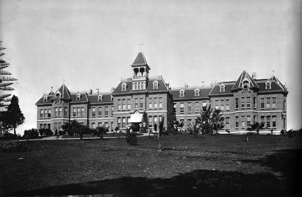
| (ca. 1887)* - Photograph of St. Vincent's Infirmary (aka Sisters Hospital) as seen from across the lawn. Several trees, most of them palms, are planted in front of the grand hospital that shows numerous windows, dormers, an irregular roof, a cupola or tower, and several chimneys. Six nuns can be seen walking and/or sitting around the front lawn. |
Historical Notes The Daughters of Charity of St. Vincent de Paul established the first hospital in Los Angeles - the Los Angeles Infirmary, in 1856. It was located in the Sonora Town adobe owned by then-Mayor of Los Angeles, Don Cristo´bal Aguilar. Four years later, in 1860, the hospital relocated to 1416 Naud Street, between Ann (named for Sister Ann) and Sotillo Street (though other data indicates the location was 1414 Naud Street, between N. Main and San Fernando Road). In 1869, Daughters incorporated the Los Angeles Infirmary under their own ownership, the first women in the region to do so. In 1883 they purchased six and a half acres of land at Beaudry Park at a cost of $10,000, and a new hospital building was erected a year later at Beaudry and Sunset, on a hillside overlooking Sonora Town. By 1898, Los Angeles Infirmary had come to be known as Sisters Hospital, but both names were used interchangeably in reference to the same hospital; in 1918, the name was officially changed to St. Vincent's Hospital. In 1924 a new building was erected on 3rd and Alvarado, which was built by John C. Austin and Frederick M. Ashley. For 47 years, the hospital had such a steady growth that they were forced to expand yet again, and groundbreaking for a newer, larger building took place in 1971 - this time, located at 2131 W. 3rd Street. With a "new" hospital came a new name, and in 1974, it changed again, this time becoming St. Vincent Medical Center. |
 |
|
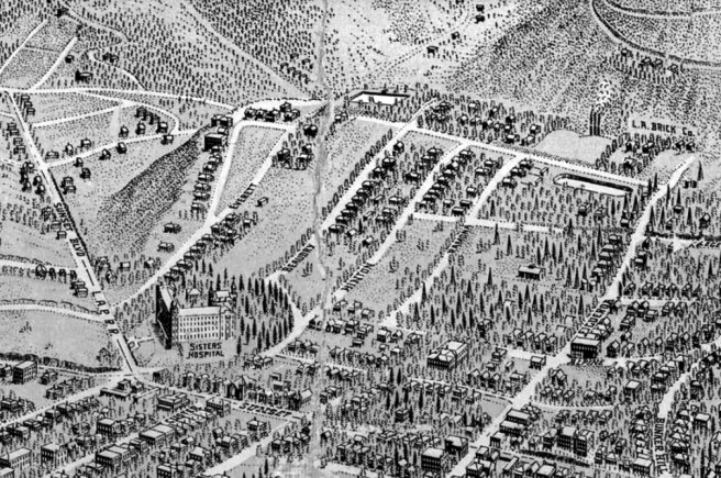
| (1909)* - Detail of Worthington Gates’s birdseye map of Los Angeles, showing Victor Heights. The Sisters Hospital is seen at lower center-left at Sunset and Beaudry. |
Historical Notes Beaudry Park was located near the intersection of Beaudry Ave. and Sunset Blvd. When acquired for a hospital by the Daughters of Charity of St. Vincent de Paul, the park was an oval-shaped parcel of open land. Sisters Hospital (originally St. Vincent's Infirmary) was built in 1884 on six and half acres of what was then known as Beuadry Park (developed by brothers Prudent and Victor Beaudry in 1876). |
 |
|
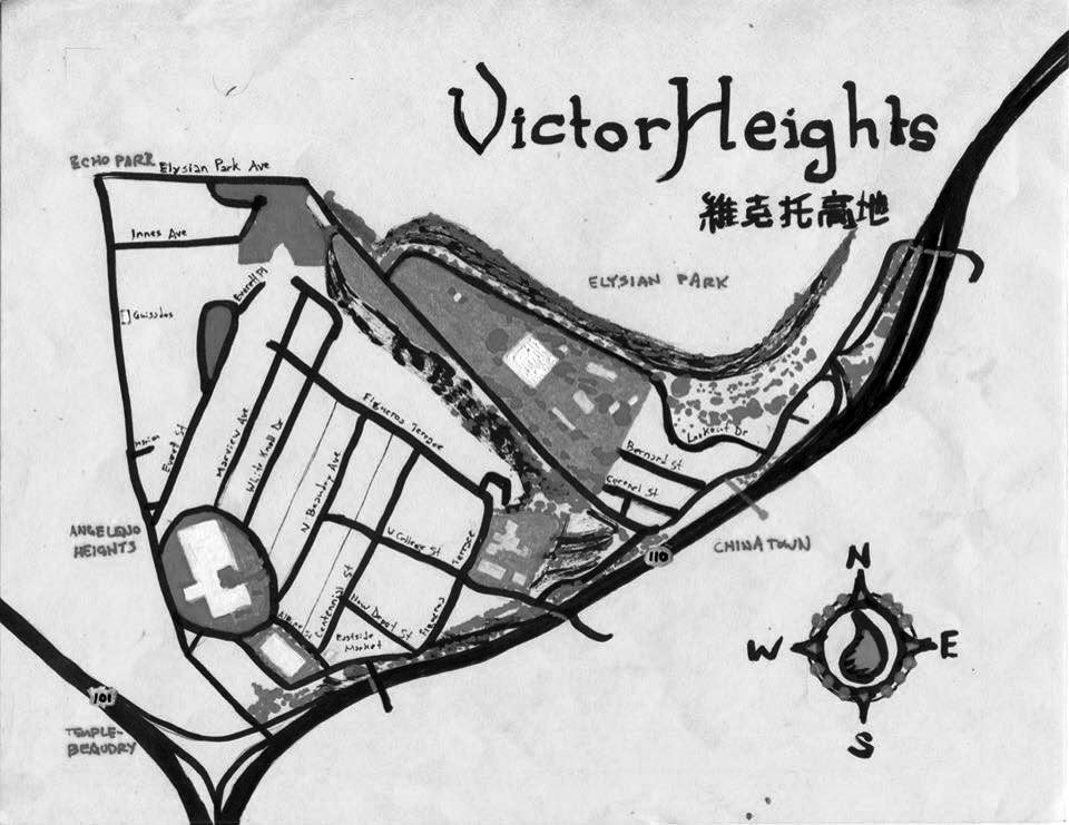
| (2010s)* - Pendersleigh & Sons Cartography‘s Map of Victor Heights. Photo Courtesy of Eric Brightwell |
Historical Notes In Victor Heights the most visible reminder of the neighborhood’s once strongly-Italian character is Eastside Market and Deli. It was opened in the 1920s by Puglia-born Domenic Pontrelli across the river in the Eastside (Lincoln Heights) before moving to its current location (1013 Alpine Street) in 1929. Back then Alpine Street was home to three other Italian Markets. It was from within Eastside Deli that Pontrelli’s son-in-law launched Pontrelli & Laricchia Sausage Company which moved out of the neighborhood in 1973. Shortly after, a former clean-up boy for the sausage company, Johnny Angiuli, took over the market with his brother, a former delivery driver, and they reorganized the establishment around a new deli counter, which is its focus today Also located within the Victor Heights is the Art Deco-style Navy and Marine Corps Reserve Center Building, designed to be the largest enclosed structure without walls in the world by architects Robert Clements and Associates. It was constructed by the WPA between 1938 and 1941 as one of the country’s largest naval armories, its secluded location chosen to shield it in the event of an air attack. During World War II, more than 20,000 sailors passed through the training center. In 1980, an electrical fire heavily damaged the interior, which reopened in 1986 after a renovation. It was designated California State Historic Landmark #972 in 1989. The military left in 1995 and it’s now home to the LAFD’s Frank Hotchkin Memorial Training Center, named after the firefighter who died fighting the 1980 conflagration. |
* * * * * |
City Garden
 |
|
| (1880s)* - Photo of an illustration showing the City Garden of Eberle Bros. located at San Pedro St. & Kohler (later 8th Street). The scene in the upper left corner shows an outdoor bowling alley. Source: The History of Los Angeles County - 1880 |
Historical Notes The 1888 Sanborn Map shows: The tracks in front of the property on San Pedro Street as Southern Pacific R.R. (Wilmington Branch); the large bulding in the rear as the 'Dancing Pavilion'; and the garden on the right as the 'Beer Garden'. |
 |
|
| (1896)* - View showing the City Gardens with windmill and surrounded by a white picket fence, located on the northeast corner of San Pedro and 8th streets. |
Historical Notes The garden covered about six acres and was notable for being the first stop the Santa Monica Railroad made out of the city. |
jpg.jpg) |
|
| (1880s)* – Detail view showing City Garden of Eberle Bros. located on the corner of San Pedro Street and Kohler (now 8th Street). Each arched entryway says City Garden. The large building in the rear has a sign reading: City Garden Pavilion - 1877. |
 |
|
| (2021)* - Contemporary view of the northeast corner of San Pedro and 8th Street where the City Garden once was located. |
Historical Notes Although the building seen here sells garments, this intersection is part of the Los Angeles Flower District, an area known for its concentration of flower markets and floral businesses. It is a hub for both wholesale and retail flower purchases. Key points about the Los Angeles Flower District: Location: The main area is centered around Wall Street, between 7th and 8th streets in downtown Los Angeles. Size and significance: It is considered the largest wholesale flower market in the United States. Composition: The district spans approximately six blocks and includes several notable flower markets: The Original Los Angeles Flower Market (754 & 755 Wall St) Southern California Flower Market (742 Maple Ave) California Flower Mall (825 S. San Pedro St) |
Then and Now
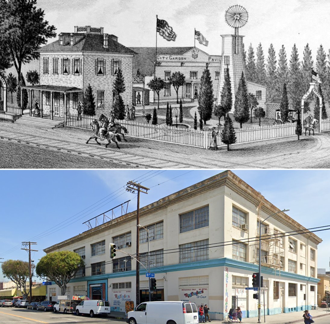 |
|
| (1880s vs 2021)* - Northeast corner of San Pedro and 8th Street, where the City Garden once existed, is now part of the Los Angeles Flower District. The City Garden covered about six acres and included a dancing pavilion, an outdoor beer garden, and one of Los Angeles' first bowling alleys. It was also notable for being the first stop of the Southern Pacific Railway line to Santa Monica out of the city. Photo comparison by Jack Feldman. |
* * * * * |
The Longstreet Mansion and the Longstreet Palms
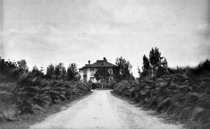 |
|
| (1870s)* - View looking north showing the Longstreet Mansion at the end of a palm-tree lined drive (later known as Palm Drive) . Amazingly the Longstreet Palms seen above are still alive today. Along with the Arcade Depot Palm, they are considered to be the oldest trees in Los Angeles. |
Historical Notes Charles A. Longstreet arrived in Los Angeles in late 1873, likely for his health. Soon after he reached the city he bought a 35 acre tract bordered by Figueroa Street, Grand Avenue, Adams Street and 23rd Street. He built a large Italianate mansion on a graded rise at the north end of a straight drive. Young fan palms were planted along both sides of the driveway. These palms grew into the line of trees seen in this early view, and many of them still survive today. |
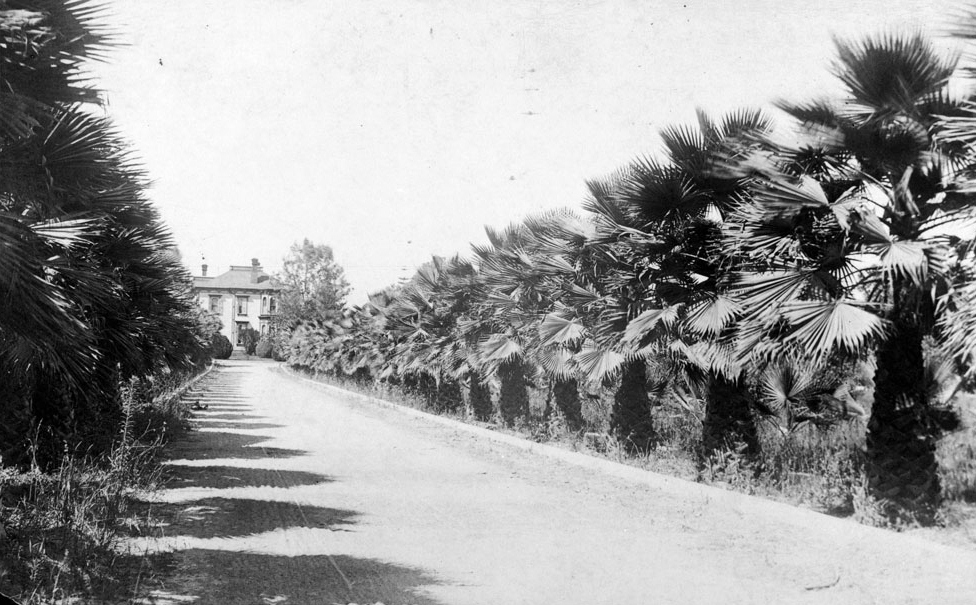 |
|
| (ca. 1880s)* - View of Palm Drive north from Adams Boulevard, showing the residence of Charles A. Longstreet (not to be confused with Confederate General James Longstreet, a distant relative of Charles). |
Historical Notes By the 1880s the Longstreet Place was known as one of the most attractive estates in Southern California. Newspapers described the graded slope, the palms, the trimmed hedges, and the flower beds as a garden of delight. At this time it was the closest thing Los Angeles had to a southern style avenue leading to a country house. The house belonged to Charles A. Longstreet, a distant relative of Confederate General James Longstreet, but the two men should not be confused with one another. |
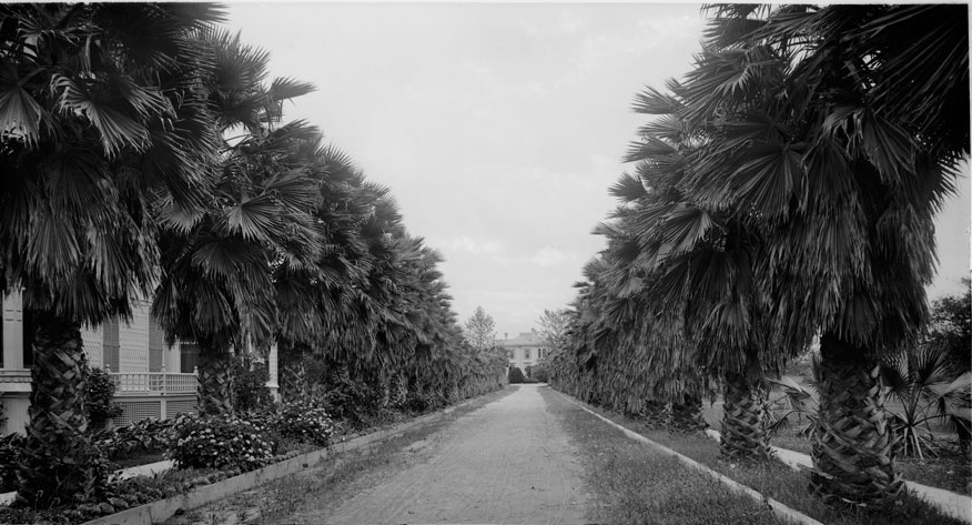 |
|
| (ca. 1886)* - Path through Charles Longstreet's homestead on Palm Drive north of Adams Boulevard. |
Historical Notes One of the hottest areas of the city for development was to the south and west of downtown, an area that first became known when Agricultural Park (now Exposition Park) was established there by 1870. A decade later, the Methodist-affiliated University of Southern California opened its doors. However, with the completion of the Santa Fe Transcontinental Railroad Line directly to Los Angeles, the floodgates were opened for the great Boom of the Eighties that rose up in 1886 and peaked the following two years. Large estates and mansions lined Figueroa Avenue, Adams Boulevard and other nearby streets and some of these had very impressive landscaping.^ Charles Longstreet had died in 1877 and his widow and 3 sons lived in the mansion until 1884, when the land was subdivided. |
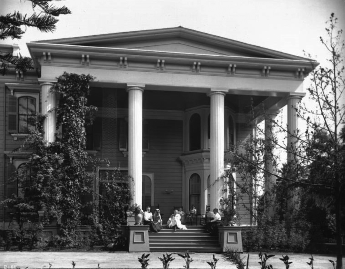 |
|
| (ca. 1895)* - View showing women sitting on the porch of the north side of the Longstreet Mansion. The home, whose column at left is overgrown with vines, was built circa 1874. The area later became Singleton Court and then Orthopedic Hospital. |
Historical Notes By the mid-1890s the Longstreet mansion was about 20 years old. Parts of the original 35 acre tract had already been sold, and new houses stood along Adams Street and the palm lined drive. The property later passed through several owners. Juana Neal, a well known businesswoman, lived in the old mansion for a time and helped sell lots from what had become known as the Longstreet Tract. The house sat on land that would later be called Singleton Court and eventually became the site of the Los Angeles Orthopaedic Hospital. |
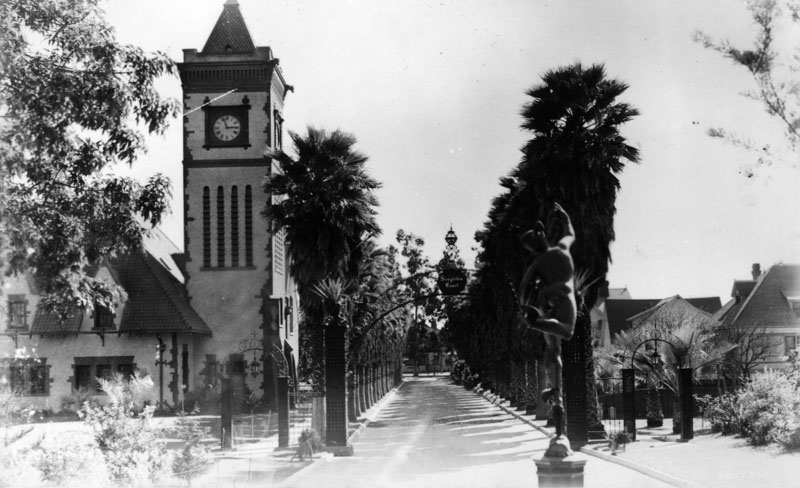 |
|
| (ca. 1910)^ - View looking south on Palm Drive toward Adams Boulevard through the Singleton Court entrance gate. |
Historical Notes Around 1899 the old Longstreet house and the remaining grounds were purchased by mining man John Singleton. He added a clock tower, made improvements to the buildings, and renamed the property Singleton Court. The main entrance was on Adams Street, marked by iron gates. This view looks south from within Singleton Court toward Adams Street. The estate then covered about 3.5 acres. Sometime before 1918 the main house was destroyed by fire, leaving only the brick stable building and the clock tower. The clock tower was later moved to the Brockman estate in Glendale. |
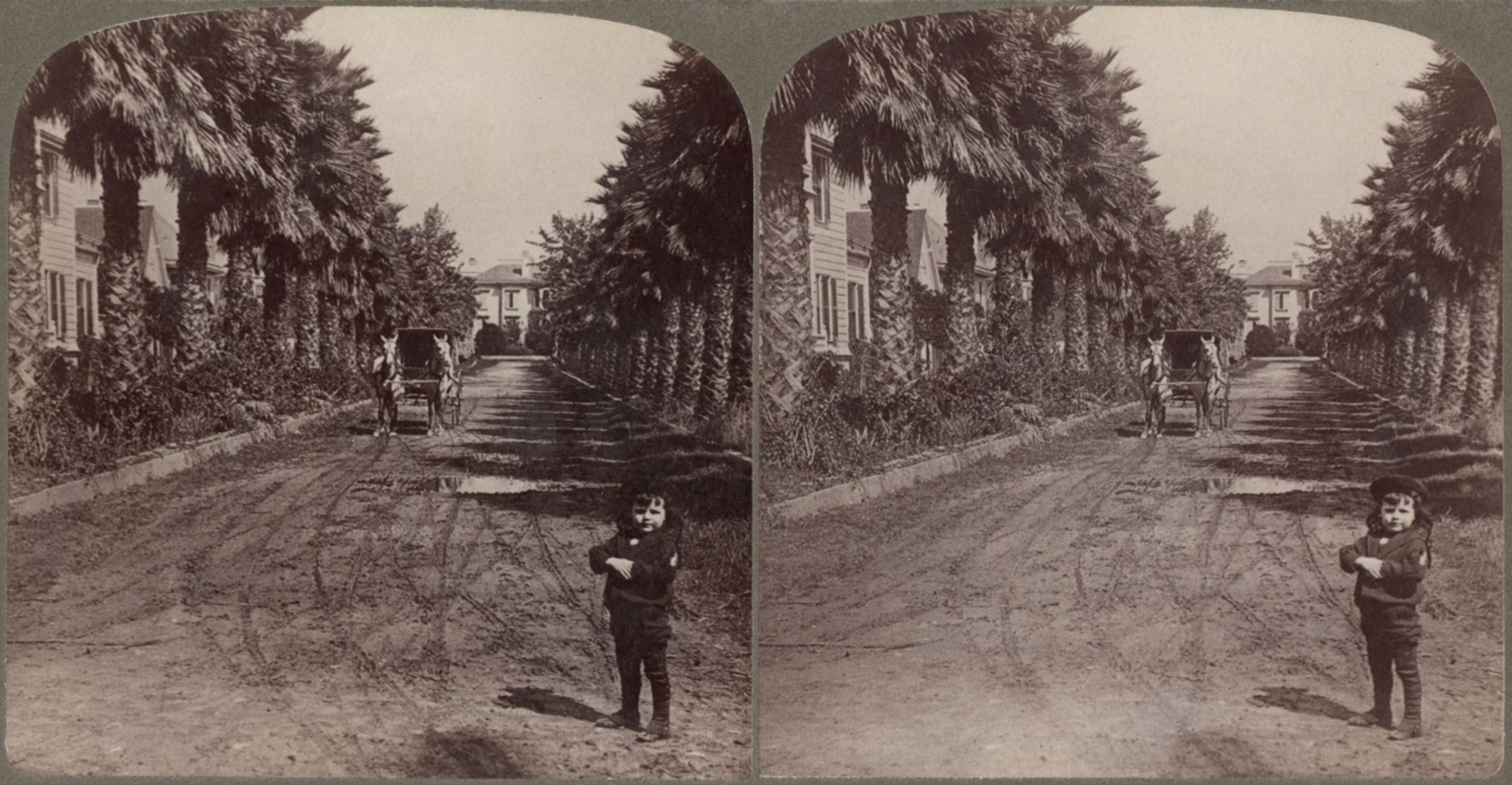 |
|
| (1909)* – Stereoscopic view looking north on Palm Drive from just above Adams Boulevard. A young child stands in the foreground while a horse-drawn carriage waits in the distance. At the end of the palm-lined street is the mansion built for Charles Longstreet, later known as the Singleton Mansion. |
Historical Notes This photo shows Palm Drive more than 30 years after Charles Longstreet planted the young fan palms along his driveway. By 1909 many of the original palms had grown into tall, mature trees. New houses and sidewalks lined the street, showing how the earlier private drive had become a public city street. A child stands in the foreground and a carriage drawn by a pair of horses waits farther up the drive. At the end of the palms stands the mansion first built for Charles A. Longstreet. By this date it was better known as John Singleton’s residence at Singleton Court. |
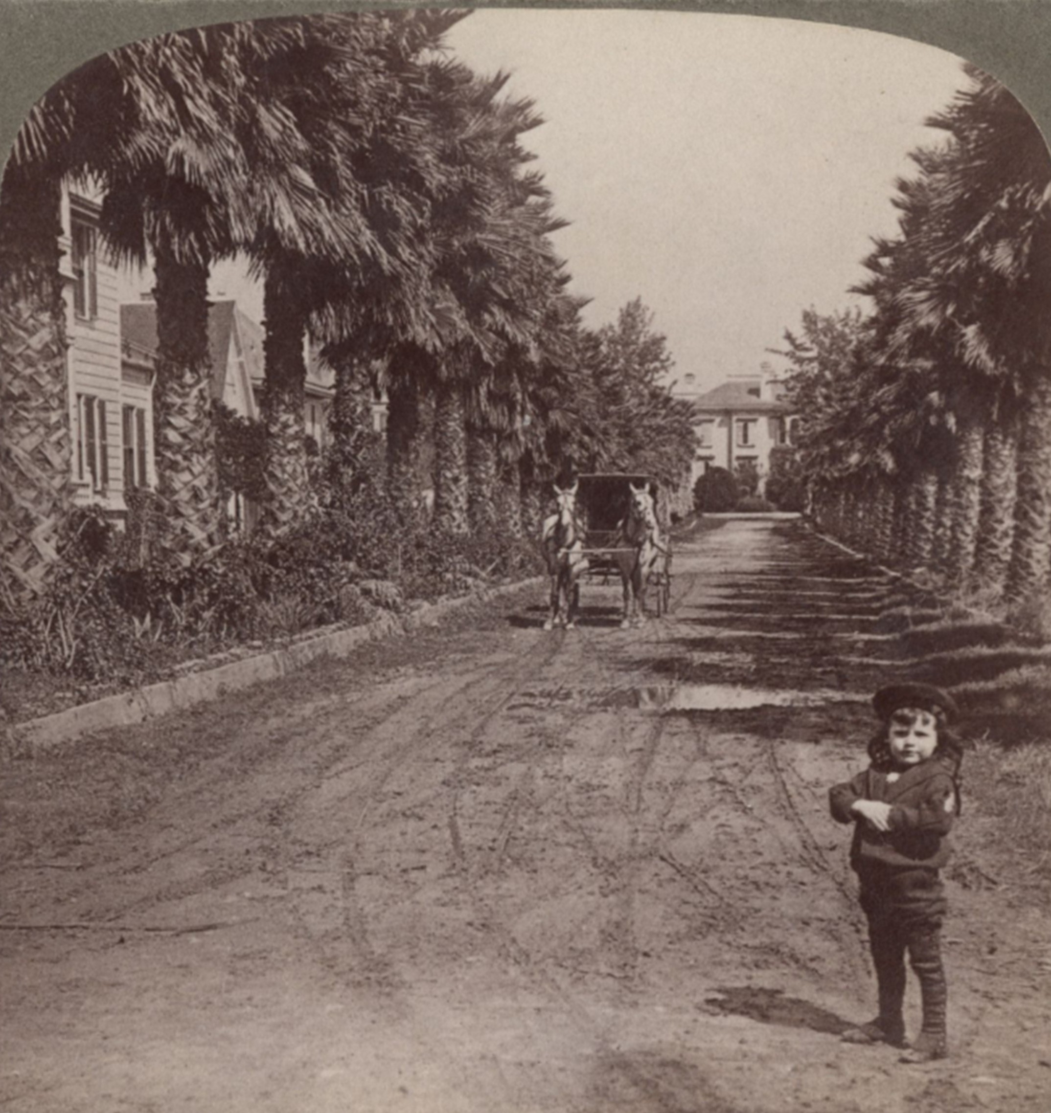 |
|
| (1909)* – Right panel of the stereoscopic view looking north on Palm Drive from just above Adams Boulevard. The tall line of Longstreet’s original fan palms frames the approach to the mansion first built for Charles A. Longstreet, later known as the Singleton Mansion. |
Historical Notes This right panel forms the second half of the 1909 stereoscopic pair. Together, the two images show how Palm Drive looked more than 30 years after Charles Longstreet planted the young fan palms along his private driveway. By this time Palm Drive had become a public street lined with new homes and sidewalks, but the tall palms still gave it the appearance of a long formal approach to the old estate. At the far north end stood the mansion first built for Charles A. Longstreet and later owned by John Singleton as part of his property called Singleton Court. |
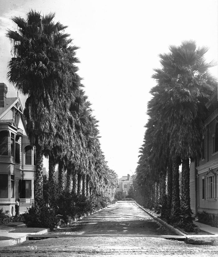 |
|
| (ca. 1920)* - Palm Drive after the turn of the century. View looking north from Adams Boulevard. |
Historical Notes By the early 1920s the palms were already known as the tallest in the city, and many believed they were also the oldest. The palm lined streets of Beverly Hills were only then being planted, while the Longstreet palms were already about 40 to 50 years old. This view looks north from Adams Street. Even as the surrounding blocks filled with houses and the old estate buildings changed hands, the palms remained the most visible reminder of the original Longstreet Place. |
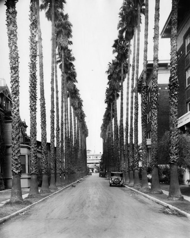 |
|
| (ca. 1930)^ - A view of Palm Drive north from Adams Boulevard, with two-story houses on either side and cars parked on the street. The building at the end of the street is the Los Angeles Orthopaedic Hospital located on the site of Charles Longstreet's former home. |
Historical Notes By 1930 the mansion was gone, and the Los Angeles Orthopaedic Hospital now stood at the north end of Palm Drive on the former Longstreet property. The hospital was founded in 1911 by Dr Charles LeRoy Lowman and expanded steadily after the first building opened in 1922. Many of the original palms still stood and became part of the hospital grounds. Together with the old Arcade Depot Palm downtown, they are often considered the oldest trees in Los Angeles. |
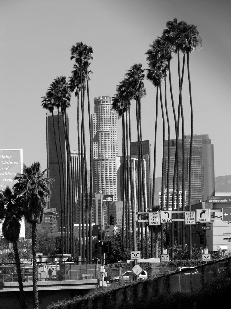 |
|
| (2010)* - The oldest Mexican Fan Palms (Washingtonia robusta) in Los Angeles. Located on what was Palm Avenue at Adams Boulevard (now on grounds of the Los Angeles Orthopaedic Hospital). Planted circa 1875. Along with the Arcade Depot Palm, they are considered to be the oldest trees in Los Angeles. Photo by Waltarrrr / Wikipedia |
Historical Notes Only about 23 of the original Longstreet palms remain today. They stand on the campus at Flower Street and Adams Boulevard. The trees are Washingtonia robusta, often called Mexican Fan Palms. They were planted in the early 1870s and are among the oldest living trees in the city. A children’s park now stands beside them, and the curved sign at the park entrance recalls the curve of the old iron gates that once marked the entrance to Singleton Court. |
* * * * * |
Please Support Our CauseWater and Power Associates, Inc. is a non-profit, public service organization dedicated to preserving historical records and photos. Your generosity allows us to continue to disseminate knowledge of the rich and diverse multicultural history of the greater Los Angeles area; to serve as a resource of historical information; and to assist in the preservation of the city's historic records.
|
More Historical Early Views
Newest Additions
Early LA Buildings and City Views
History of Water and Electricity in Los Angeles
* * * * * |
References and Credits
* DWP - LA Public Library Image Archive
^ LA Public Library Image Archive
*# Historical Society of Southern California: Eternity Street; Phineas Banning
+# A Visit to Old Los Angeles - CSULB.edu
+^ Old Los Angeles and Environs blogspot
#^ Huntington Digital Library Archive
***Los Angeles Historic - Cultural Monuments Listing
*^*California Historical Landmarks Listing (Los Angeles)
*^#Public Art in LA: Campo Santo
*##Metro.net - Los Angeles Transit History
^##California State Library Image Archive
**#The Cable-Car-Guy.com: The Los Angeles Railway
*#*KCET - When the Cahuenga Pass Was Rustic
^*#Noirish Los Angeles - forum.skyscraperpage.com; 2nd and Broadway
^^#CSULB - A Visit to Old LA: Hamburger Dept. Store; Main Street
**^History Matters: Calle de los Negros, 1880s
^^*LA Fire Department Historical Archive
^***Homestead Museum: Workman and Temple Family
^^*#Jewish Museum of the American West: Jacoby Brothers
*^^^Los Angeles Orthopaedic Hospital
*^^*Los Angeles Past: Temple and Main Streets, Los Angeles - Then and Now; Longstreet Palms; Palm Drive Then and Now
*#^#Los Angeles Athletic Club History
**## Mojave Desert.net: Remi Nadeau
#***Photos of Vintage Los Angeles - Facebook.com: 1899 Bunker Hill
#^^#Cal State Pomona Archive: Lichtenberger's Carriage Factory
*^ Wikipedia: Arcadia Bandini de Stearns Baker; Bunker Hill; Prudent Beaudry; Jonathan Temple; Los Angeles High School; Joseph Widney; Pershing Square; Port of Los Angeles; Belmont High School; Hollenbeck Park; Ducommun; Isaias W. Hellman; Abel Stearns; Sawtelle Veterans Home; Arcade Station; Alhambra; Fort Moore; History of Santa Monica; History of Los Angeles; Burbank; John Schumacher; History of Los Angeles Population Growth; Telegraphy; Felix Signoret; Helen Hunt Jackson; Hill Street; Cahuenga Peak; Angelino Heights; LA's Oldest Palm Trees; Cathedral of Saint Vibiana; Harris Newmark
< Back